
Size of this preview:
800 × 576 pixels. Other resolutions:
320 × 230 pixels |
640 × 460 pixels |
1,024 × 737 pixels |
1,280 × 921 pixels |
2,560 × 1,842 pixels |
8,948 × 6,437 pixels.
Original file (8,948 × 6,437 pixels, file size: 19.62 MB, MIME type: image/jpeg)
| This is a file from the
Wikimedia Commons. Information from its
description page there is shown below. Commons is a freely licensed media file repository. You can help. |
Summary
| Title |
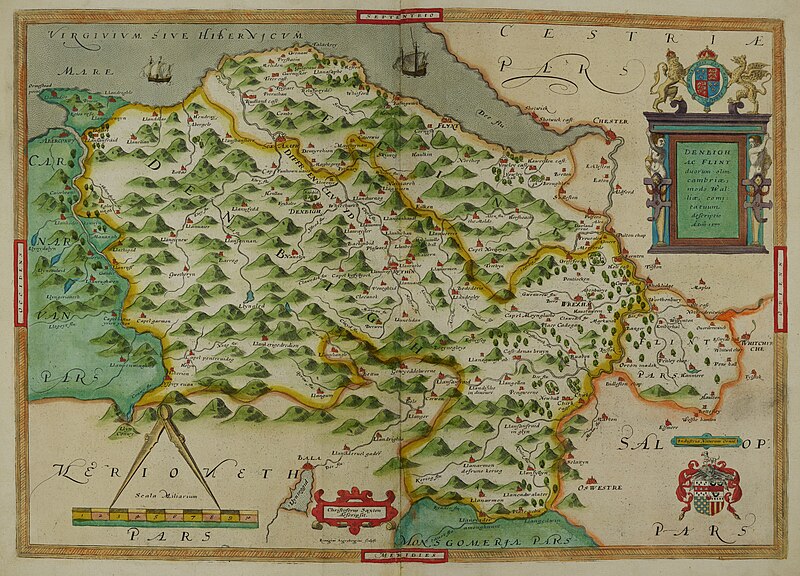
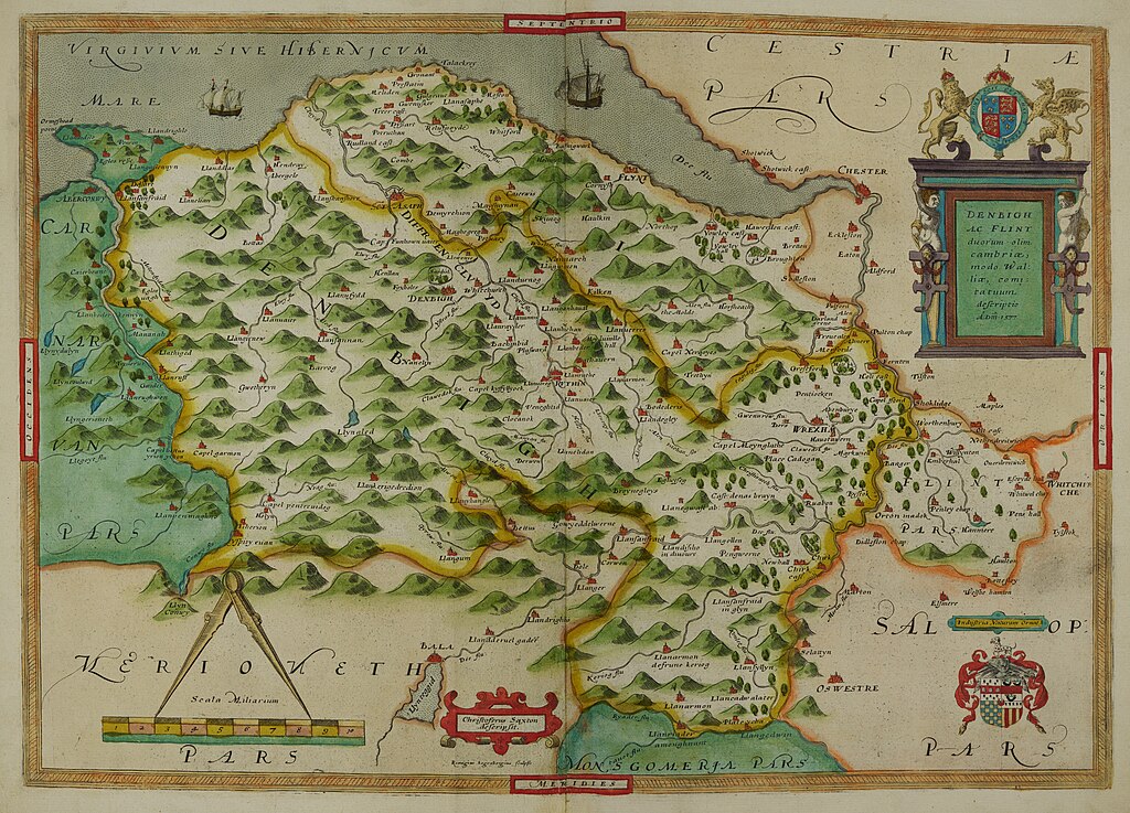
Latina: Dinbigh Flint Atlas |
|||||||||||||
| Description |
English: Atlas created by cartographer Christopher Saxton in 1576 as part of his 'Atlas of the Counties of England and Wales'. Contains hand-written marginal notes. |
|||||||||||||
| Date | ||||||||||||||
| Source | This file has been provided by the University of Exeter, Special Collections. Image captured by University of Exeter Digital Humanities and taken from Dinbigh Flint 1576; C Saxton's Atlas of England and Wales. | |||||||||||||
| Creator |
|
|||||||||||||
| Credit line | University of Exeter Special Collections | |||||||||||||
| Permission ( Reusing this file) |
CC0 | |||||||||||||
| Geotemporal data | ||||||||||||||
| Date depicted | ||||||||||||||
| Map location | [Anglesey and Caernarnan] | |||||||||||||
| Map type | County Map | |||||||||||||
| Georeferencing | If inappropriate please set warp_status = skip to hide. | |||||||||||||
| Bibliographic data | ||||||||||||||
| Publication |
Atlas of the Counties of England and Wales |
|||||||||||||
| Author |
|
|||||||||||||
| Language | Latin | |||||||||||||
| Place of publication | London | |||||||||||||
| Archival data | ||||||||||||||
| Collection | University of Exeter Special Collections; Rare Books Collection. | |||||||||||||
| Accession number |
Rare books B 1590/SAX/XX |
|||||||||||||
| Dimensions | 550mm x 430mm | |||||||||||||
| Medium | Printed; hand coloured. | |||||||||||||
| Other versions |
File: Dinbigh Flint Atlas.tif
|
|||||||||||||
Licensing
| This file is made available under the Creative Commons CC0 1.0 Universal Public Domain Dedication. | |
| The person who associated a work with this deed has dedicated the work to the
public domain by waiving all of their rights to the work worldwide under copyright law, including all related and neighboring rights, to the extent allowed by law. You can copy, modify, distribute and perform the work, even for commercial purposes, all without asking permission.
|
File history
Click on a date/time to view the file as it appeared at that time.
| Date/Time | Thumbnail | Dimensions | User | Comment | |
|---|---|---|---|---|---|
| current | 18:12, 5 July 2023 |
| 8,948 × 6,437 (19.62 MB) | MarianneDelacroix | Uploaded a work by Christopher Saxton from This file has been provided by the University of Exeter, Special Collections. Image captured by University of Exeter Digital Humanities and taken from Dinbigh flint Map 1576; C Saxton's Atlas of England and Wales. with UploadWizard |
File usage
The following pages on the English Wikipedia use this file (pages on other projects are not listed):