
Size of this PNG preview of this SVG file:
361 × 600 pixels. Other resolutions:
144 × 240 pixels |
289 × 480 pixels |
462 × 768 pixels |
616 × 1,024 pixels |
1,233 × 2,048 pixels |
602 × 1,000 pixels.
Original file (SVG file, nominally 602 × 1,000 pixels, file size: 249 KB)
| This is a file from the
Wikimedia Commons. Information from its
description page there is shown below. Commons is a freely licensed media file repository. You can help. |
.svg)
Summary
| Description |
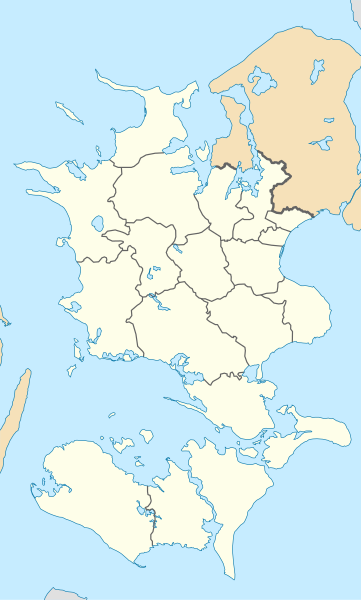
English: Location map of Region Zealand in Denmark, color adjusted
Equirectangular projection, N/S stretching 176 %. Geographic limits of the map:
Deutsch: Positionskarte von der Region Sjæland in Dänemark, Farben wurden angepasst
Quadratische Plattkarte, N-S-Streckung 176 %. Geographische Begrenzung der Karte:
|
| Date | |
| Source | Own work |
| Author | Erik Frohne |
| Other versions | Denmark Zealand location map.svg |
| SVG development |
Licensing
I, the copyright holder of this work, hereby publish it under the following licenses:

|
Permission is granted to copy, distribute and/or modify this document under the terms of the GNU Free Documentation License, Version 1.2 or any later version published by the Free Software Foundation; with no Invariant Sections, no Front-Cover Texts, and no Back-Cover Texts. A copy of the license is included in the section entitled GNU Free Documentation License. |
This file is licensed under the
Creative Commons
Attribution-Share Alike 3.0 Unported license.
- You are free:
- to share – to copy, distribute and transmit the work
- to remix – to adapt the work
- Under the following conditions:
- attribution – You must give appropriate credit, provide a link to the license, and indicate if changes were made. You may do so in any reasonable manner, but not in any way that suggests the licensor endorses you or your use.
- share alike – If you remix, transform, or build upon the material, you must distribute your contributions under the same or compatible license as the original.
You may select the license of your choice.
File history
Click on a date/time to view the file as it appeared at that time.
| Date/Time | Thumbnail | Dimensions | User | Comment | |
|---|---|---|---|---|---|
| current | 13:19, 13 January 2010 |
| 602 × 1,000 (249 KB) | Erik Frohne | == {{int:filedesc}} == {{Information |Description={{en|1=Location map of Region Zealand in Denmark, color adjusted Equirectangular projection, N/S stretching 176 %. Geographic limits of the map: * N: 56.20° N * S: 54.50° N * W: 10.80° E * E: 12.60° |
File usage
More than 100 pages use this file. The following list shows the first 100 pages that use this file only. A full list is available.
.svg)
- Algestrup
- Asnæs
- Bisserup
- Bjæverskov
- Boeslunde
- Borup, Køge Municipality
- Dalby, Faxe Municipality
- Dalmose
- Dybsø
- Ejby, Køge Municipality
- Ejby, Lejre Municipality
- Eskilstrup
- Faxe
- Faxe Ladeplads
- Flakkebjerg
- Forlev-Vemmelev
- Frølunde Fed
- Fuglebjerg
- Gadstrup
- Gevninge
- Glumsø
- Gundsømagle
- Gørlev
- Haslev
- Havdrup
- Havrebjerg
- Hillested
- Holbæk
- Holeby
- Hvalsø
- Hårlev
- Højby
- Høng
- Idestrup
- Jyderup
- Jyllinge
- Jystrup
- Kalundborg
- Karise
- Kirke Stillinge
- Knabstrup
- Kongsmark Strand
- Korsør
- Kundby
- Køge
- Køge North railway station
- Køge railway station
- Køng
- Lejre
- Lille Skensved
- Lindholm (Stege Bugt)
- Lundby, Vordingborg Municipality
- Magleby, Stevns Municipality
- Maribo
- Mern
- Nakskov
- Nordbyen
- Nykøbing Sjælland
- Nyråd
- Nysted
- Næstved
- Nørre Alslev
- Osted
- Præstø
- Ringsted
- Roskilde
- Roskilde railway station
- Rude (Slagelse Municipality)
- Ruds Vedby
- Rågø
- Rødby
- Rødbyhavn
- Rønnede
- Rørvig
- Sakskøbing
- Sandved, Denmark
- Skalø
- Skælskør
- Slagelse
- Slots Bjergby
- Solrød Strand railway station
- Sorø
- Stege, Denmark
- Stensved
- Stillinge Strand
- Store Damme
- Store Heddinge
- Store Merløse
- Stubbekøbing
- Svenstrup (Slagelse Municipality)
- Svinninge, Holbæk Municipality
- Svogerslev
- Søllested
- Sørbymagle
- Tune, Denmark
- Tuse
- Tølløse
- Undløse
- Viby, Roskilde Municipality
- Vindinge, Roskilde Municipality
View more links to this file.
Global file usage
The following other wikis use this file:
- Usage on da.wikipedia.org
- Næstved
- Brorfelde
- Maribo
- Møns Klint
- Ringsted
- Roskilde Domkirke
- Iselingen
- Suså
- Slagelse
- Roskilde
- Rødbyhavn
- Sorø
- Kalvehave
- Jyderup
- Køge
- Agersø
- Vejlø (Nakskov Fjord)
- Nysted
- Nakskov
- Vordingborg
- Ønslev
- Hyllinge (Næstved Kommune)
- Gørlev
- Tissø
- Krønge
- Klaus Nars Holm
- Præstø
- Store Heddinge
- Korsør
- Skælskør
- Orø
- Lystrup (Kongsted Sogn)
- Gåsetårnet
- Vedde
- Nykøbing Sjælland
- Sundby (Lolland)
- Nykøbing Falster
- CELF
- Kalundborg
- Gedser
- Osted
- Slotø
- Barneholm
- Smedeholm
- Kåreholm
- Munkeholm
- Rommerholm
- Enehøje
- Askø (Smålandsfarvandet)
- Lilleø (Smålandsfarvandet)
View more global usage of this file.
.svg)
.svg)