
Size of this preview:
473 × 599 pixels. Other resolutions:
189 × 240 pixels |
379 × 480 pixels |
606 × 768 pixels |
808 × 1,024 pixels |
1,616 × 2,048 pixels |
4,582 × 5,805 pixels.
Original file (4,582 × 5,805 pixels, file size: 4.3 MB, MIME type: image/jpeg)
| This is a file from the
Wikimedia Commons. Information from its
description page there is shown below. Commons is a freely licensed media file repository. You can help. |
Summary
| Description |
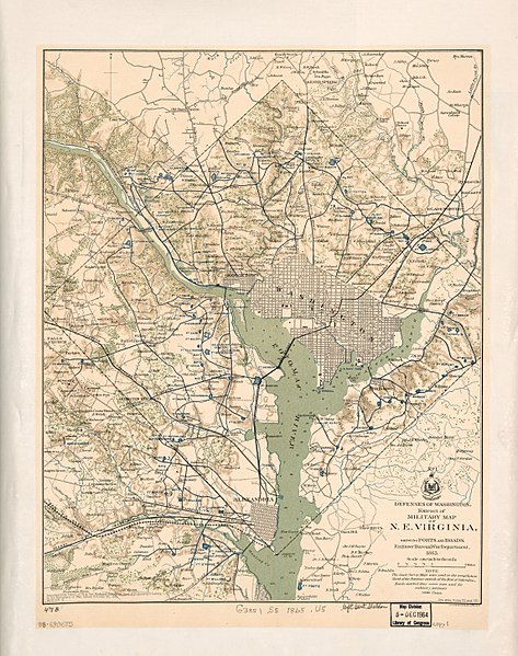
English: Relief shown by hachures. Depths shown by soundings. Also shows woods and householders' names in rural areas. In lower left corner: Accompanying report of Brig. Gen. Richard Delafield ... dated October 30, 1865, series III. From: Atlas to accompany the official records of the Union and Confederate Armies, Washington, 1891-1895, plate 89, map 1. In lower right corner: See Atlas, Plates VII. and VIII. Includes note and coat of arms. At head of coat of arms: No. 1. LC copy 1 laminated and mounted on cloth backing; copy 2 fold-lined and mounted on paper backing. Available also through the Library of Congress Web site as a raster image. 3 copies DCP |
||
| Title | Defenses of Washington, extract of military map of N.E. Virginia : showing forts and roads | ||
| Shelf ID | G3851.S5 1865 .U5 | ||
| Date | |||
| Source | https://www.loc.gov/item/88690675/ | ||
| Author | United States. War Department. Engineer Bureau; Delafield, Richard; United States. Government Printing Office | ||
| Permission ( Reusing this file) |
|
||
| Other versions |
|
||
| Location | United States · Washington D.C. · Washington Metropolitan Area · Washington · District Of Columbia | ||
| Part of | American Memory · Catalog · County Landownership Maps · Geography And Map Division · Cultural Landscapes | ||
| Subject | Washington (D.C.) · Washington Metropolitan Area · Fortification · Washington · Civil War · United States · Maps · District Of Columbia · Real Property · History |


Licensing
|
This is a faithful photographic reproduction of a two-dimensional,
public domain work of art. The work of art itself is in the public domain for the following reason:
The official position taken by the Wikimedia Foundation is that "faithful reproductions of two-dimensional public domain works of art are public domain".
This photographic reproduction is therefore also considered to be in the public domain in the United States. In other jurisdictions, re-use of this content may be restricted; see Reuse of PD-Art photographs for details. | ||||
File history
Click on a date/time to view the file as it appeared at that time.
| Date/Time | Thumbnail | Dimensions | User | Comment | |
|---|---|---|---|---|---|
| current | 07:05, 16 May 2018 |
| 4,582 × 5,805 (4.3 MB) | Fæ | LOC Maps https://www.loc.gov/item/88690675/ #909 |
File usage
The following pages on the English Wikipedia use this file (pages on other projects are not listed):
Global file usage
The following other wikis use this file:
- Usage on www.wikidata.org