
Size of this preview:
760 × 600 pixels. Other resolutions:
304 × 240 pixels |
608 × 480 pixels |
974 × 768 pixels |
1,280 × 1,010 pixels |
2,560 × 2,020 pixels |
4,569 × 3,605 pixels.
Original file (4,569 × 3,605 pixels, file size: 2.22 MB, MIME type: image/jpeg)
| This is a file from the
Wikimedia Commons. Information from its
description page there is shown below. Commons is a freely licensed media file repository. You can help. |
|
This is an image of a place or building that is listed on the
National Register of Historic Places in the
United States of America. Its reference number is
92000166. |
Summary
| Description |
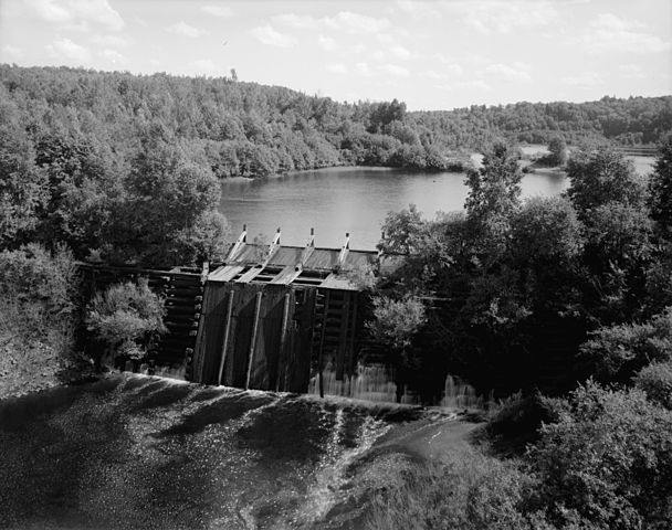
English: Redridge Timber Crib Dam,
Salmon Trout River, Beacon Hill, Houghton County, MI. This dam preceded the
Redridge Steel Dam and was inundated by it. After that dam was taken out of service, it was exposed again. |
| Date | |
| Source | Historic American Engineering Record, Library of Congress HAER MICH,31-BEHIL,2-1 |
| Author | Photographer: Jet Lowe |
| Permission ( Reusing this file) |
{{PD-USGov-Interior-HABS}} |
| Camera location |
| View this and other nearby images on: OpenStreetMap |
|
|---|
Note: Compare with Image:Redridge_MI_Old_Wooden_DamDSCN2188.JPG, taken about 30 years later in July 2008.
Licensing

|
This file comes from the
Historic American Buildings Survey (HABS), Historic American Engineering Record (HAER) or Historic American Landscapes Survey (HALS). These are programs of the National Park Service established for the purpose of documenting historic places. Records consist of measured drawings, archival photographs, and written reports.
|
| This image or media file contains material based on a work of a National Park Service employee, created as part of that person's official duties. As a work of the U.S. federal government, such work is in the public domain in the United States. See the NPS website and NPS copyright policy for more information. |
File history
Click on a date/time to view the file as it appeared at that time.
| Date/Time | Thumbnail | Dimensions | User | Comment | |
|---|---|---|---|---|---|
| current | 09:07, 13 April 2008 |
| 4,569 × 3,605 (2.22 MB) | Finavon | border cropped |
| 18:15, 23 January 2006 |
 | 4,823 × 3,853 (2.34 MB) | Duk | Redridge Timber Crib Dam, Salmon Trout River, Beacon Hill, Houghton County, MI *Creator: Historic American Engineering Record [http://hdl.loc.gov/loc.pnp/hhh.mi0144] *Photographer: Jet Lowe, HAER photographer, July 1978 [http://memory.loc.gov/pnp/habsha |
File usage
The following pages on the English Wikipedia use this file (pages on other projects are not listed):
Global file usage
The following other wikis use this file:
- Usage on es.wikipedia.org
- Usage on ko.wikipedia.org
- Usage on ml.wikipedia.org
- Usage on mn.wikipedia.org
- Usage on ms.wikipedia.org
- Usage on sv.wikipedia.org
- Usage on uk.wikipedia.org