
Size of this JPG preview of this TIF file:
800 × 572 pixels. Other resolutions:
320 × 229 pixels |
640 × 457 pixels |
1,024 × 732 pixels |
1,280 × 914 pixels |
2,560 × 1,829 pixels |
5,000 × 3,572 pixels.
Original file (5,000 × 3,572 pixels, file size: 17.04 MB, MIME type: image/tiff)
| This is a file from the
Wikimedia Commons. Information from its
description page there is shown below. Commons is a freely licensed media file repository. You can help. |
Summary
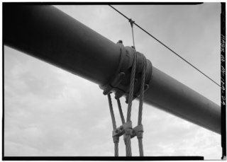
| DETAIL SHOWING SUSPENDER CABLE AND SADDLE - George Washington Bridge, Spanning Hudson River between Manhattan and Fort Lee, NJ, New York, New York County, NY | ||||
|---|---|---|---|---|
| Photographer |
Related names:
|
|||
| Title |
DETAIL SHOWING SUSPENDER CABLE AND SADDLE - George Washington Bridge, Spanning Hudson River between Manhattan and Fort Lee, NJ, New York, New York County, NY |
|||
| Depicted place | New York; New York County; New York | |||
| Date | Documentation compiled after 1968 | |||
| Dimensions | 5 x 7 in. | |||
| Current location |
Library of Congress Prints and Photographs Division Washington, D.C. 20540 USA
http://hdl.loc.gov/loc.pnp/pp.print |
|||
| Accession number |
HAER NY,31-NEYO,161-29 |
|||
| Credit line |
|
|||
| Notes |
|
|||
| Source | https://www.loc.gov/pictures/item/ny1264.photos.119062p | |||
| Permission ( Reusing this file) |
|
|||

| Object location |
| View this and other nearby images on: OpenStreetMap |
|
|---|
File history
Click on a date/time to view the file as it appeared at that time.
| Date/Time | Thumbnail | Dimensions | User | Comment | |
|---|---|---|---|---|---|
| current | 16:13, 29 July 2014 |
 | 5,000 × 3,572 (17.04 MB) | Fæ | GWToolset: Creating mediafile for Fæ. HABS 24 July 2014 (2301:2600) |
File usage
The following pages on the English Wikipedia use this file (pages on other projects are not listed):