
Size of this preview:
512 × 599 pixels. Other resolutions:
205 × 240 pixels |
410 × 480 pixels |
656 × 768 pixels |
1,230 × 1,440 pixels.
Original file (1,230 × 1,440 pixels, file size: 2.9 MB, MIME type: image/jpeg)
| This is a file from the
Wikimedia Commons. Information from its
description page there is shown below. Commons is a freely licensed media file repository. You can help. |
Summary
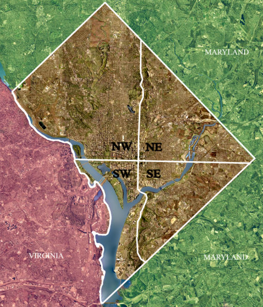
| Description | USGS satellite image of the District of Columbia, modified to show territorial boundary and quadrant divisions. |
| Date | Taken on 26 April 2002 |
| Source | USGS satellite image |
| Author | USGS, modified by User:Postdlf |
| Other versions |
|
.jpg)
.jpg)

Licensing
This image is in the
public domain in the United States because it only contains materials that originally came from the
United States Geological Survey, an agency of the
United States Department of the Interior. For more information, see
the official USGS copyright policy.
|
File history
Click on a date/time to view the file as it appeared at that time.
| Date/Time | Thumbnail | Dimensions | User | Comment | |
|---|---|---|---|---|---|
| current | 14:41, 1 November 2006 |
| 1,230 × 1,440 (2.9 MB) | Urban~commonswiki | Uploaded from : http://upload.wikimedia.org/wikipedia/en/d/d7/DC_satellite_image.jpg == Summary == USGS satellite image of Washington, D.C. taken April 26, 2002, modified to show territorial boundary and quadrant di |
File usage
The following pages on the English Wikipedia use this file (pages on other projects are not listed):
Global file usage
The following other wikis use this file:
- Usage on af.wikipedia.org
- Usage on ar.wikipedia.org
- Usage on be.wikipedia.org
- Usage on ca.wikipedia.org
- Usage on eml.wikipedia.org
- Usage on es.wikipedia.org
- Usage on fr.wikipedia.org
- Usage on hu.wikipedia.org
- Usage on id.wikipedia.org
- Usage on it.wikipedia.org
- Usage on ja.wikipedia.org
- Usage on ko.wikipedia.org
- Usage on mwl.wikipedia.org
- Usage on pl.wikipedia.org
- Usage on pt.wikipedia.org
- Usage on ro.wikipedia.org
- Usage on ru.wikipedia.org
- Usage on sh.wikipedia.org
- Usage on sr.wikipedia.org
- Usage on sv.wikipedia.org
- Usage on ta.wikipedia.org
- Usage on tr.wikipedia.org
- Usage on ur.wikipedia.org
- Usage on vi.wikipedia.org
- Usage on www.wikidata.org
- Usage on zh.wikipedia.org
View more global usage of this file.