Size of this preview:
800 × 521 pixels. Other resolutions:
320 × 208 pixels |
640 × 416 pixels |
1,024 × 666 pixels |
1,280 × 833 pixels |
2,560 × 1,666 pixels |
3,590 × 2,336 pixels.
Original file (3,590 × 2,336 pixels, file size: 9.9 MB, MIME type: image/jpeg)
| This is a file from the
Wikimedia Commons. Information from its
description page there is shown below. Commons is a freely licensed media file repository. You can help. |
Summary
| Description |
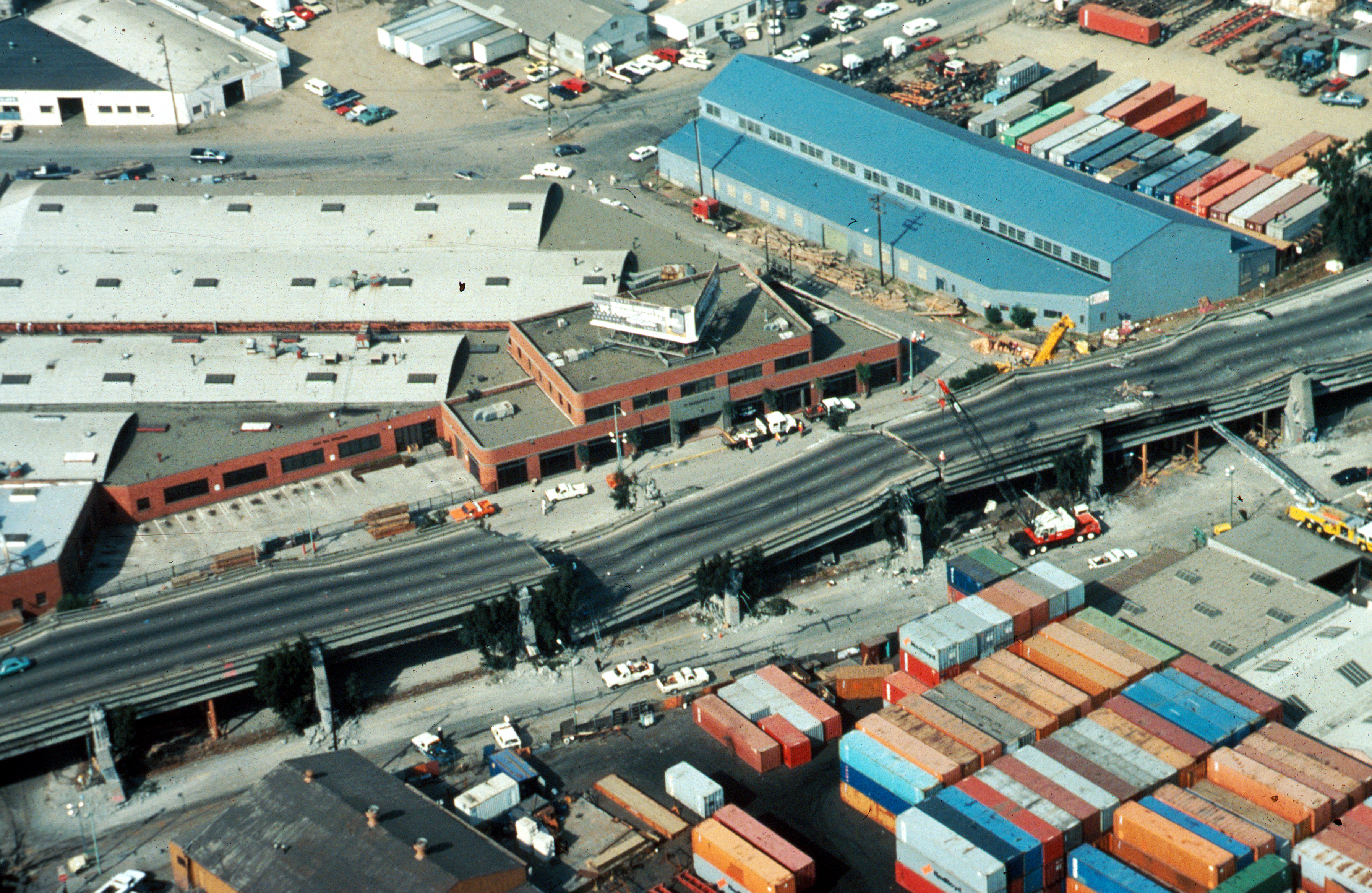
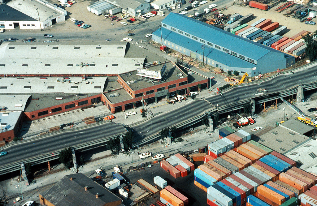
USGS photo from 1989 Loma Prieta earthquake. Caption: Aerial view of collapsed sections of the en:Cypress Viaduct of en:Interstate 880. [H.G. Wilshire, U.S. Geological Survey] |
| Date | |
| Source |
Photo by H. G. Wilshire for U.S. Geological Survey. High res version on line at : [1] Lower resolution version: Original image here: http://pubs.usgs.gov/dds/dds-29/web_pages/oakland.html |
| Author | H.G. Wilshire, U.S. Geological Survey |
| Permission ( Reusing this file) |
PD-USGOV-INTERIOR-USGS. |
| Other versions |
|

Licensing
This image is in the
public domain in the United States because it only contains materials that originally came from the
United States Geological Survey, an agency of the
United States Department of the Interior. For more information, see
the official USGS copyright policy.
|
File history
Click on a date/time to view the file as it appeared at that time.
| Date/Time | Thumbnail | Dimensions | User | Comment | |
|---|---|---|---|---|---|
| current | 17:57, 16 October 2009 |
| 3,590 × 2,336 (9.9 MB) | Infrogmation | High res version |
| 05:27, 30 November 2006 |
 | 763 × 512 (64 KB) | Zzyzx11 | {{Information |Description=[http://wrgis.wr.usgs.gov/dds/dds-29/ USGS photo] from 1989 en:Loma Prieta earthquake. '''Caption''': Aerial view of collapsed sections of the en:Cypress Viaduct of en:Interstate 880. [H.G. Wilshire, U.S. Geolo |
File usage
The following pages on the English Wikipedia use this file (pages on other projects are not listed):
- 1989 Loma Prieta earthquake
- 1989 in the United States
- Cypress Street Viaduct
- Interstate 880 (California)
- MacArthur Maze
- Oakland, California
- Seismic microzonation
- User:DiRkdARyL
- User:Jer10 95/earthquakeprone
- Wikipedia:Selected anniversaries/October 17
- Wikipedia talk:WikiProject Userboxes/New Userboxes/Archive 13
- Portal:San Francisco Bay Area/Selected article/18
- Portal:San Francisco Bay Area/Selected article/Archive
Global file usage
The following other wikis use this file:
- Usage on af.wikipedia.org
- Usage on ar.wikipedia.org
- Usage on azb.wikipedia.org
- Usage on az.wikipedia.org
- Usage on bg.wikipedia.org
- Usage on da.wikipedia.org
- Usage on de.wikipedia.org
- Usage on de.wikivoyage.org
- Usage on es.wikipedia.org
- Usage on fi.wikipedia.org
- Usage on he.wikipedia.org
- Usage on hi.wikipedia.org
- Usage on id.wikipedia.org
- Usage on it.wikipedia.org
- Usage on ja.wikipedia.org
- Usage on ko.wikipedia.org
- Usage on ms.wikipedia.org
- Usage on pam.wikipedia.org
- Usage on pl.wikipedia.org
- Usage on pt.wikipedia.org
- Usage on ro.wikipedia.org
- Usage on ru.wikipedia.org
- Usage on simple.wikipedia.org
- Usage on sr.wikipedia.org
- Usage on sv.wikipedia.org
- Usage on th.wikipedia.org
- Usage on tr.wikipedia.org
- Usage on uk.wikipedia.org
- Usage on www.wikidata.org
- Usage on zh-yue.wikipedia.org
- Usage on zh.wikipedia.org