No higher resolution available.
Cumbernauld_from_the_air_(geograph_5629257).jpg (640 × 480 pixels, file size: 171 KB, MIME type: image/jpeg)
| This is a file from the
Wikimedia Commons. Information from its
description page there is shown below. Commons is a freely licensed media file repository. You can help. |
.jpg)
Summary
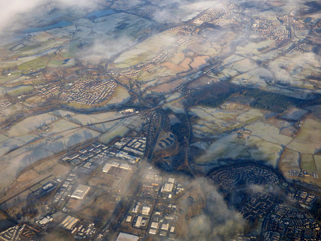
| Description |
English: Cumbernauld from the air
The M80 motorway can be seen heading north to Stirling via Castlecary, where the Forth & Clyde canal and the main Glasgow to Edinburgh railway both cross (one under, one over). Banknock and Bonnybridge are also visible. |
| Date | |
| Source | From geograph.org.uk |
| Author | Thomas Nugent |
| Permission ( Reusing this file) |
Creative Commons Attribution Share-alike license 2.0 |
| Attribution ( required by the license) | Thomas Nugent / Cumbernauld from the air / |
| Object location | | View this and other nearby images on: OpenStreetMap |
|
|---|
.jpg¶ms=055.965830_N_-003.964090_E_globe:Earth_class:object_type:object_source:geograph-osgb36(NS7776)_heading:22.00&language=en)
Licensing

|
This image was taken from the
Geograph project collection. See
this photograph's page on the Geograph website for the photographer's contact details. The copyright on this image is owned by Thomas Nugent and is licensed for reuse under the
Creative Commons Attribution-ShareAlike 2.0 license.
|
This file is licensed under the
Creative Commons
Attribution-Share Alike 2.0 Generic license.
Attribution: Thomas Nugent
- You are free:
- to share – to copy, distribute and transmit the work
- to remix – to adapt the work
- Under the following conditions:
- attribution – You must give appropriate credit, provide a link to the license, and indicate if changes were made. You may do so in any reasonable manner, but not in any way that suggests the licensor endorses you or your use.
- share alike – If you remix, transform, or build upon the material, you must distribute your contributions under the same or compatible license as the original.
Original upload log
The original description page was
here. All following user names refer to en.wikipedia.
| Date/Time | Dimensions | User | Comment |
|---|---|---|---|
| 2018-01-27 17:45 | 640×480× (175597 bytes) | AndrasSkot | Uploading a file from a free published source using [[Wikipedia:File_Upload_Wizard|File Upload Wizard]] |
File history
Click on a date/time to view the file as it appeared at that time.
| Date/Time | Thumbnail | Dimensions | User | Comment | |
|---|---|---|---|---|---|
| current | 11:19, 29 December 2018 |
| 640 × 480 (171 KB) | Junior Jumper | Transferred from geograph.co.uk using [https://tools.wmflabs.org/geograph2commons/ geograph2commons] |
File usage
The following pages on the English Wikipedia use this file (pages on other projects are not listed):
.jpg)