
Size of this PNG preview of this SVG file:
800 × 559 pixels. Other resolutions:
320 × 224 pixels |
640 × 447 pixels |
1,024 × 716 pixels |
1,280 × 894 pixels |
2,560 × 1,789 pixels |
1,039 × 726 pixels.
Original file (SVG file, nominally 1,039 × 726 pixels, file size: 450 KB)
| This is a file from the
Wikimedia Commons. Information from its
description page there is shown below. Commons is a freely licensed media file repository. You can help. |
Summary
| Description |
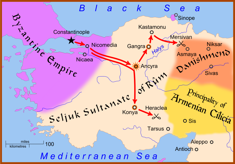
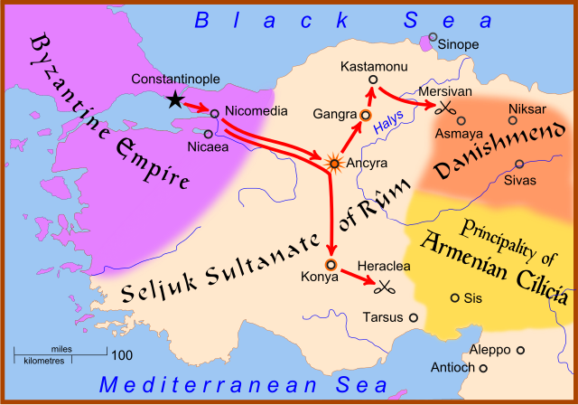
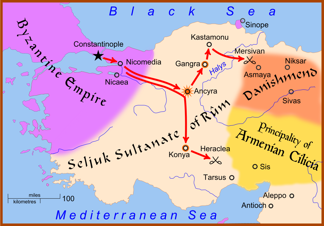
English: A map showing the movements of Christian armies in
Anatolia during the
Crusade of 1101.
The star at Ancyra indicates that the city was taken by the Crusaders. A circle around a city, as at Konya and Gangra, indicates that the city was placed under siege but was not taken. |
| Date | |
| Source | Own work based on: Anatolia 1097.svg |
| Author | MapMaster |
| Other versions |
|


References
- Hammond World Atlas Corporation (2007) Historical World Atlas, ISBN 9-780843-71391-6
- Fisher, Sydney Nettleton (2000) The Foreign Relations of Turkey 1481-1512, Electronic Journal of Oriental Studies
- Runciman, Steven, A History of the Crusades, vol. 2: The Kingdom of Jerusalem and the Frankish East, 1100-1187, Cambridge University Press, 1951.
Licensing
I, the copyright holder of this work, hereby publish it under the following licenses:

|
Permission is granted to copy, distribute and/or modify this document under the terms of the GNU Free Documentation License, Version 1.2 or any later version published by the Free Software Foundation; with no Invariant Sections, no Front-Cover Texts, and no Back-Cover Texts. A copy of the license is included in the section entitled GNU Free Documentation License. |
This file is licensed under the
Creative Commons Attribution-Share Alike
4.0 International,
3.0 Unported,
2.5 Generic,
2.0 Generic and
1.0 Generic license.
- You are free:
- to share – to copy, distribute and transmit the work
- to remix – to adapt the work
- Under the following conditions:
- attribution – You must give appropriate credit, provide a link to the license, and indicate if changes were made. You may do so in any reasonable manner, but not in any way that suggests the licensor endorses you or your use.
- share alike – If you remix, transform, or build upon the material, you must distribute your contributions under the same or compatible license as the original.
You may select the license of your choice.
File history
Click on a date/time to view the file as it appeared at that time.
| Date/Time | Thumbnail | Dimensions | User | Comment | |
|---|---|---|---|---|---|
| current | 16:16, 28 February 2008 |
| 1,039 × 726 (450 KB) | MapMaster | Not Mervisan, but Mersivan |
| 22:04, 27 February 2008 |
 | 1,039 × 726 (457 KB) | MapMaster | {{Information |Description=A map showing the movements of Christian armies in Anatolia during the Crusade of 1101 |Source=self-made |Date=27 Feb 2008 |Author= MapMaster |Permission= |other_ver |
File usage
The following pages on the English Wikipedia use this file (pages on other projects are not listed):
Global file usage
The following other wikis use this file:
- Usage on ast.wikipedia.org
- Usage on azb.wikipedia.org
- Usage on bg.wikipedia.org
- Usage on bn.wikipedia.org
- Usage on ca.wikipedia.org
- Usage on cs.wikipedia.org
- Usage on da.wikipedia.org
- Usage on de.wikipedia.org
- Usage on el.wikipedia.org
- Usage on et.wikipedia.org
- Usage on eu.wikipedia.org
- Usage on fr.wikipedia.org
- Usage on hu.wikipedia.org
- Usage on id.wikipedia.org
- Usage on ja.wikipedia.org
- Usage on ko.wikipedia.org
- Usage on nl.wikipedia.org
- Usage on no.wikipedia.org
- Usage on pl.wikipedia.org
- Usage on ro.wikipedia.org
- Usage on ru.wikipedia.org
- Usage on sh.wikipedia.org
- Usage on sl.wikipedia.org
- Usage on sq.wikipedia.org
- Usage on sr.wikipedia.org
- Usage on tr.wikipedia.org
- Usage on uk.wikipedia.org
View more global usage of this file.