
Original file (SVG file, nominally 742 × 812 pixels, file size: 1.73 MB)
| This is a file from the
Wikimedia Commons. Information from its
description page there is shown below. Commons is a freely licensed media file repository. You can help. |
| Description |
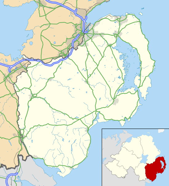
Map of County Down, UK with the following information shown:
Geographic limits:
|
|||
| Date | ||||
| Source |
Ordnance Survey of Northern Ireland OpenData
Ordnance Survey OpenData
|
|||
| Author | Nilfanion, created using OSNI data | |||
| Permission ( Reusing this file) |
This file is licensed under the
Creative Commons
Attribution-Share Alike 3.0 Unported license. Attribution: Contains LPS Intellectual Property and Ordnance Survey data © Crown copyright and database right 2016
|
File history
Click on a date/time to view the file as it appeared at that time.
| Date/Time | Thumbnail | Dimensions | User | Comment | |
|---|---|---|---|---|---|
| current | 12:45, 15 May 2016 |
| 742 × 812 (1.73 MB) | Nilfanion | {{Information |Description=Map of County Down, UK with the following information shown: *Administrative borders *Coastline, lakes and rivers *Roads and railways *Urban areas Equirectangular map projection on WGS 84 datum, with N/S s... |
File usage
More than 100 pages use this file. The following list shows the first 100 pages that use this file only. A full list is available.
- 1920–21 Irish League
- 1921–22 Irish League
- 1922–23 Irish League
- Annaclone
- Annahilt
- Annalong
- Ardglass
- Atticall
- Ballela
- Balloo, County Down
- Ballygowan
- Ballyhackamore
- Ballyhalbert
- Ballykinler
- Ballynahinch, County Down
- Ballynoe, County Down
- Ballyskeagh
- Ballywalter
- Banbridge
- Bangor, County Down
- Bangor Abbey
- Benraw
- Blackskull
- Bleary
- Bryansford
- Burr Point
- Burren, County Down
- Cabra, County Down
- Carnalea
- Carryduff
- Castlewellan
- Comber
- Conlig
- Copeland Islands
- Corbet
- Crawfordsburn
- Crossgar
- Cultra
- Derryneill
- Dollingstown
- Donaghadee
- Donaghcloney
- Downpatrick
- Dromara
- Dromore, County Down
- Drumaness
- Drumbo
- Dundonald, County Down
- Dundrum, County Down
- Edenderry, County Down
- Gilford, County Down
- Greyabbey
- Groomsport
- Helen's Bay
- Hilltown, County Down
- Holywood, County Down
- Katesbridge
- Kilcoo
- Kilkeel
- Killough
- Killyleagh
- Kinallen
- Kircubbin, County Down
- La Mon restaurant bombing
- Lawrencetown, County Down
- Leitrim, County Down
- List of monastic houses in Ireland
- Lough Island Reavy
- Loughbrickland
- Loughinisland
- Lurganare
- Magheralin
- Mayobridge
- Mazetown
- Millisle
- Moira, County Down
- Moneyreagh
- Nendrum Monastery
- Newcastle, County Down
- Newtownards
- Newtownards Airport
- Portaferry
- Portavogie
- Páirc Esler
- Rathfriland
- Rostrevor
- Royal County Down Golf Club
- Royal Hillsborough
- Saintfield
- Scarva
- Seahill
- Silent Valley Reservoir
- Slieve Donard
- Spelga Reservoir
- Strangford
- Tullylish
- Ulster Folk and Transport Museums
- Waringsford
- Waringstown
- Warrenpoint
View more links to this file.
Global file usage
The following other wikis use this file:
- Usage on fa.wikipedia.org
- فرودگاه نیوتاوناردز
- بنگور، شهرستان داون
- کوربست
- آناهیلت
- پودمان:Location map United Kingdom County Down
- الگو:Location map United Kingdom County Down
- آردگلاس
- بالیهالبرت
- بالیواتر
- کرافوردزبرن
- کراسگار
- دوناگکلونی
- داونپتریک
- درومارا
- داندروم، کاونتی داون
- اسکاروا
- هیلزبورو، شهرستان داون
- هیلتاون، شهرستان داون
- کیلکی
- کیلاگ
- مایوبریج
- مویرا، شهرستان داون
- نیوکاسل، شهرستان داون
- نیوتاوناردز
- پورتافری
- رتفریلند
- روسترور
- سنتفیلد
- استرانگفورد
- وارینگزتاون
- وارنپوینت
- تولیلیش
- وارینگزفورد
- میزتاون
- میل آیل
- کینالن
- لوگینآیلند
- خلیج هلن
- ادندری، شهرستان داون
- گرومسپورت
- Usage on fr.wikipedia.org
- Usage on ja.wikipedia.org
- Usage on sco.wikipedia.org
- Usage on si.wikipedia.org
- Usage on uz.wikipedia.org
- Usage on zh.wikipedia.org
View more global usage of this file.