Size of this preview:
753 × 600 pixels. Other resolutions:
302 × 240 pixels |
603 × 480 pixels |
795 × 633 pixels.
Original file (795 × 633 pixels, file size: 75 KB, MIME type: image/jpeg)
| This is a file from the
Wikimedia Commons. Information from its
description page there is shown below. Commons is a freely licensed media file repository. You can help. |
|
This is an image of a place or building that is listed on the
National Register of Historic Places in the
United States of America. Its reference number is
88000837. |
| Camera location |
| View this and other nearby images on: OpenStreetMap |
|
|---|
| Description |
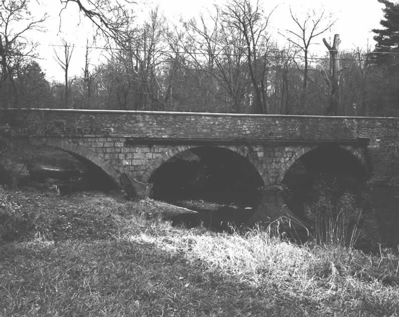
English: Side of the
County Bridge No. 54, which carries Morris Road over a branch of
Wissahickon Creek near
Prospectville in
Whitemarsh Township,
Montgomery County,
Pennsylvania,
United States. Built in 1841, this multi-span stone arch bridge is listed on the
National Register of Historic Places. |
|||
| Date | ||||
| Source | "County Bridge No. 54" (National Register of Historic Places form). National Park Service (June 22, 1988). Photo from http://www.arch.state.pa.us, searchable database, at http://www.arch.state.pa.us/images/hires/H000209_01B.jpg | |||
| Author | PennDOT | |||
| Permission ( Reusing this file) |
|

File history
Click on a date/time to view the file as it appeared at that time.
| Date/Time | Thumbnail | Dimensions | User | Comment | |
|---|---|---|---|---|---|
| current | 19:10, 14 December 2009 |
| 795 × 633 (75 KB) | Nyttend | {{Location|40|8|22|N|75|13|1|W}} {{Information |Description={{en|Side of the {{w|County Bridge No. 54}}, which carries Morris Road over a branch of {{w|Wissahickon Creek}} near {{w|Prospectville, Pennsylvania|Prospectville}} in {{w|Whitemarsh Township, Mo |
File usage
The following pages on the English Wikipedia use this file (pages on other projects are not listed):
Global file usage
The following other wikis use this file:
- Usage on www.wikidata.org