
Size of this PNG preview of this SVG file:
703 × 599 pixels. Other resolutions:
282 × 240 pixels |
563 × 480 pixels |
901 × 768 pixels |
1,201 × 1,024 pixels |
2,403 × 2,048 pixels |
2,581 × 2,200 pixels.
Original file (SVG file, nominally 2,581 × 2,200 pixels, file size: 7.2 MB)
| This is a file from the
Wikimedia Commons. Information from its
description page there is shown below. Commons is a freely licensed media file repository. You can help. |
Summary
| Description |
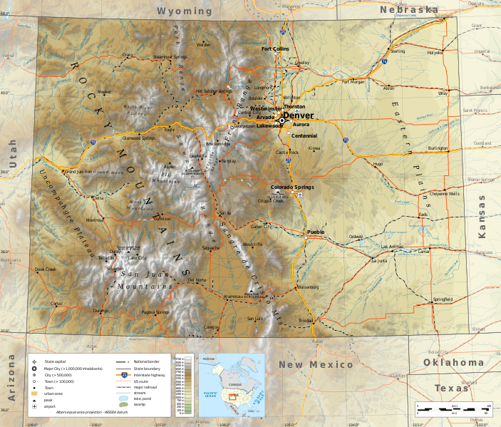
English: Geographic map of
Colorado in English. Geographic limits of the map:
|
||
| Date | |||
| Source |
Own work
|
||
| Author | Ikonact | ||
| Permission ( Reusing this file) |
Any use of this map is subject of the license(s) stated below with the condition that you credit ( Wikimedia Commons user: Ikonact) as the author . A message with a reply address would also be greatly appreciated. | ||
| SVG development |
|
Licensing
I, the copyright holder of this work, hereby publish it under the following license:
This file is licensed under the
Creative Commons
Attribution-Share Alike 4.0 International license.
- You are free:
- to share – to copy, distribute and transmit the work
- to remix – to adapt the work
- Under the following conditions:
- attribution – You must give appropriate credit, provide a link to the license, and indicate if changes were made. You may do so in any reasonable manner, but not in any way that suggests the licensor endorses you or your use.
- share alike – If you remix, transform, or build upon the material, you must distribute your contributions under the same or compatible license as the original.
File history
Click on a date/time to view the file as it appeared at that time.
| Date/Time | Thumbnail | Dimensions | User | Comment | |
|---|---|---|---|---|---|
| current | 19:49, 19 June 2020 |
| 2,581 × 2,200 (7.2 MB) | Ikonact | eastern plains |
| 11:30, 23 October 2019 |
 | 2,581 × 2,200 (6.7 MB) | Ikonact | svg valid, fall back font | |
| 21:21, 22 October 2019 |
 | 2,581 × 2,200 (7.2 MB) | Ikonact | ++ | |
| 20:53, 22 October 2019 |
 | 2,581 × 2,200 (7.2 MB) | Ikonact | mountain names | |
| 22:03, 21 October 2019 |
 | 2,581 × 2,200 (7.19 MB) | Ikonact | + names | |
| 21:41, 21 October 2019 |
 | 2,581 × 2,200 (7.19 MB) | Ikonact | == {{int:filedesc}} == {{Information |description={{en|1=Geographic map of Colorado in English. Geographic limits of the map:}} *N: 41.20° N *S: 38.80° N *W: 109.40° W *E: 101.60° W Albers equal area projection; WGS 84 datum |date=2019-10-21 |source={{own}} *Sources of data:<br/> **Topography: ETOPO1 (public domain);<br/> **Public domain data provided by the National Atlas of the United States of America;<br/> *Tool:<br/> **The map is created with Octave scripts developed by... |
File usage
The following pages on the English Wikipedia use this file (pages on other projects are not listed):
Global file usage
The following other wikis use this file:
- Usage on ang.wikipedia.org
- Usage on be.wikipedia.org
- Usage on bg.wikipedia.org
- Usage on ca.wikipedia.org
- Usage on es.wikipedia.org
- Usage on fr.wikipedia.org
- Usage on ga.wikipedia.org
- Usage on gl.wikipedia.org
- Usage on hu.wikipedia.org
- Usage on hy.wikipedia.org
- Usage on id.wikipedia.org
- Usage on it.wikipedia.org
- Usage on lo.wikipedia.org
- Usage on mhr.wikipedia.org
- Usage on os.wikipedia.org
- Usage on tg.wikipedia.org
- Usage on tt.wikipedia.org
- Usage on tum.wikipedia.org
- Usage on www.wikidata.org