Size of this preview:
645 × 599 pixels. Other resolutions:
258 × 240 pixels |
517 × 480 pixels |
759 × 705 pixels.
Original file (759 × 705 pixels, file size: 318 KB, MIME type: image/jpeg)
| This is a file from the
Wikimedia Commons. Information from its
description page there is shown below. Commons is a freely licensed media file repository. You can help. |
Summary
| Description |
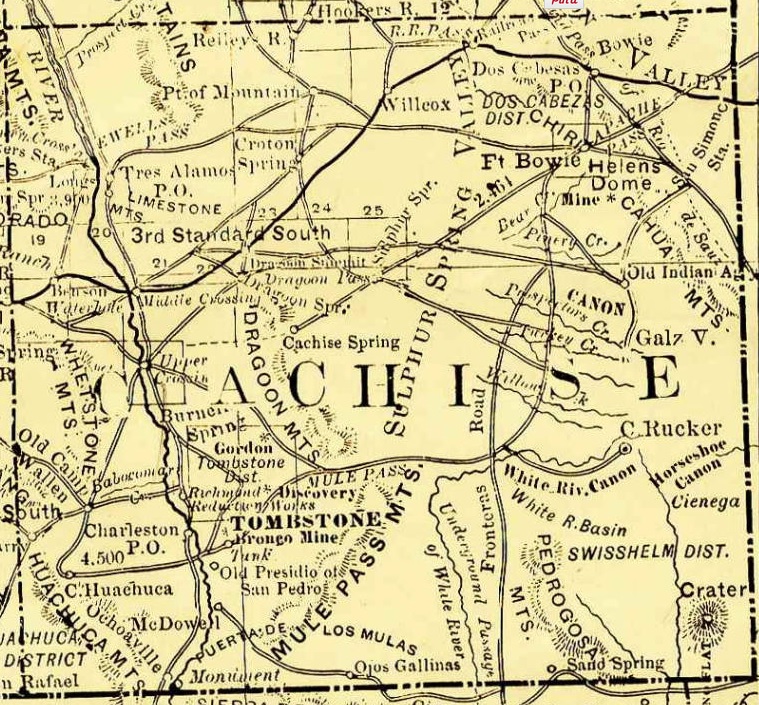
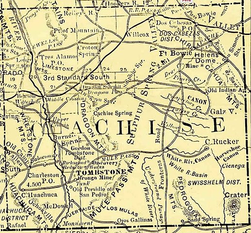
English: Arizona, 1881, map showing roads, railroads, towns, mines, mountains and rivers. Enlarged and cropped Cochise County portion of map. |
| Date | |
| Source | http://azmemory.azlibrary.gov/cdm/singleitem/collection/shmmaps/id/126 |
| Author | Rand, McNally and Company |
Licensing
This media file is in the
public domain in the
United States. This applies to U.S. works where the copyright has expired, often because its first
publication occurred prior to January 1, 1929, and if not then due to lack of notice or renewal. See
this page for further explanation.
|
 | |
 |
This image might not be in the public domain outside of the United States; this especially applies in the countries and areas that do not apply the
rule of the shorter term for US works, such as Canada, Mainland China (not Hong Kong or Macao), Germany, Mexico, and Switzerland. The creator and year of publication are essential information and must be provided. See
Wikipedia:Public domain and
Wikipedia:Copyrights for more details.
|
File history
Click on a date/time to view the file as it appeared at that time.
| Date/Time | Thumbnail | Dimensions | User | Comment | |
|---|---|---|---|---|---|
| current | 18:55, 22 September 2015 |
| 759 × 705 (318 KB) | Btphelps | User created page with UploadWizard |
File usage
The following pages on the English Wikipedia use this file (pages on other projects are not listed):
- Ben Sippy
- Benson, Arizona
- Billy Breakenridge
- Billy Claiborne
- Billy Clanton
- Bisbee, Arizona
- Buckskin Frank Leslie
- C. S. Fly
- Charles A. Shibell
- Charles Smith (cowboy)
- Charleston, Arizona
- Cochise County, Arizona
- Cochise County Cowboys
- Cochise County in the Old West
- Contention City, Arizona
- Crawley P. Dake
- Dan Tipton
- Doc Holliday
- Earp Vendetta Ride
- Ed Schieffelin
- Fairbank, Arizona
- Fort Huachuca
- Frank McLaury
- Frank Stilwell
- Fred J. Dodge
- Fred White (marshal)
- George McKelvey (lawman)
- George W. Parsons
- Guadalupe Canyon Massacre
- Guadalupe Mountains (Hidalgo County)
- Gunfight at the O.K. Corral
- Henry Hooker
- I Married Wyatt Earp
- Ike Clanton
- Jack Taylor Gang
- James Earp
- John Clum
- John Horton Slaughter
- Johnny Behan
- Johnny Ringo
- Josephine Earp
- Mattie Blaylock
- Michael O'Rourke (gambler)
- Morgan Earp
- Newman Haynes Clanton
- O.K. Corral hearing and aftermath
- Pete Spence
- Phineas Clanton
- Pony Diehl
- Robert H. Paul
- San Simon, Arizona
- Sherman McMaster
- Skeleton Canyon massacres
- Ten Percent Ring
- Texas Jack Vermillion
- Tom McLaury
- Tombstone, Arizona
- Tucson, Arizona
- Turkey Creek Jack Johnson
- Virgil Earp
- Warren Earp
- William Brocius
- William Tattenbaum
- Wyatt Earp
- User:Btphelps/Sandbox/Fred Dodge
- User:Hutcher/Cochise
- User:Hutcher/Jim Crane (cowboy)
- Wikipedia:Help desk/Archives/2020 May 6
- Template:Cochise County in the Old West
Global file usage
The following other wikis use this file:
- Usage on sr.wikipedia.org