
Size of this preview:
800 × 523 pixels. Other resolutions:
320 × 209 pixels |
640 × 418 pixels |
1,024 × 669 pixels |
1,280 × 836 pixels |
2,560 × 1,672 pixels |
6,031 × 3,939 pixels.
Original file (6,031 × 3,939 pixels, file size: 7.37 MB, MIME type: image/jpeg)
| This is a file from the
Wikimedia Commons. Information from its
description page there is shown below. Commons is a freely licensed media file repository. You can help. |
Summary
| Description |
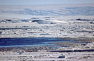
English: Antarctic coast in the vicinity of Port Martin, Adélie Land, facing south. Summer pack ice in the foreground. The coastline shows rare rock outcrops. The background shows the steep slope of the Antarctic ice sheet, which gives the impression of a huge overhanging ice wall to an observer ashore. Crevasses in the ice sheet are due to the proximity of the Zélée Glacier, a coastal glacier that flows to the right of the photograph. Below the crevassed zone, a rocky band follows a gentle slope upwards: this is the Lacroix Nunatak, which reaches an altitude of 88 m on the right.
Français : La côte antarctique au voisinage de Port-Martin, en terre Adélie (vue en direction du sud). Pack lâche d'été au premier plan. Seuls quelques rares affleurements rocheux sont visibles le long de la côte. En arrière plan, la calotte glaciaire antarctique : sa pente assez raide donne l'impression à un observateur situé en mer d'un véritable mur de glace qui surplombe la côte. La zone de crevasses est due à la proximité du glacier de la Zélée, qui s'écoule vers la droite. Sous la zone de crevasses, une fine bande rocheuse s'élève régulièrement vers la droite : c'est le nunatak Lacroix, qui atteint une altitude de 88 m sur la droite. |
| Date | |
| Source | Self-photographed |
| Author | Pepys |
Licensing
I, the copyright holder of this work, hereby publish it under the following licenses:

|
Permission is granted to copy, distribute and/or modify this document under the terms of the GNU Free Documentation License, Version 1.2 or any later version published by the Free Software Foundation; with no Invariant Sections, no Front-Cover Texts, and no Back-Cover Texts. A copy of the license is included in the section entitled GNU Free Documentation License. |
This file is licensed under the
Creative Commons Attribution-Share Alike
4.0 International,
3.0 Unported,
2.5 Generic,
2.0 Generic and
1.0 Generic license.
- You are free:
- to share – to copy, distribute and transmit the work
- to remix – to adapt the work
- Under the following conditions:
- attribution – You must give appropriate credit, provide a link to the license, and indicate if changes were made. You may do so in any reasonable manner, but not in any way that suggests the licensor endorses you or your use.
- share alike – If you remix, transform, or build upon the material, you must distribute your contributions under the same or compatible license as the original.
You may select the license of your choice.
File history
Click on a date/time to view the file as it appeared at that time.
| Date/Time | Thumbnail | Dimensions | User | Comment | |
|---|---|---|---|---|---|
| current | 17:51, 20 March 2023 |
| 6,031 × 3,939 (7.37 MB) | Pepys | {{Information |Description=Antarctic coast in the vicinity of Port-Martin, Adélie Land (Antarctica), facing south. Summer pack ice in the foreground. The coastline shows rare rock outcrops. The background shows the steep slope of the Antarctic ice sheet, which gives the impression of a huge overhanging ice wall to an observer ashore. |Source={{own}} |Date=December 1976 |Author= Pepys |Permission= |other_versions= }} |
File usage
The following pages on the English Wikipedia use this file (pages on other projects are not listed):
Global file usage
The following other wikis use this file:
- Usage on fr.wikipedia.org
- Usage on it.wikipedia.org