
Size of this PNG preview of this SVG file:
538 × 599 pixels. Other resolutions:
215 × 240 pixels |
431 × 480 pixels |
689 × 768 pixels |
919 × 1,024 pixels |
1,838 × 2,048 pixels |
700 × 780 pixels.
Original file (SVG file, nominally 700 × 780 pixels, file size: 139 KB)
| This is a file from the
Wikimedia Commons. Information from its
description page there is shown below. Commons is a freely licensed media file repository. You can help. |
Summary
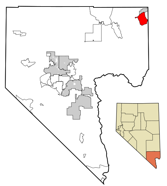
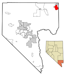
| Description | This map shows the incorporated areas in Clark County, Nevada. Bunkerville is highlighted in red. I created it in Inkscape using data from the following files: Census 2000 Block Map - Clark County ( PDF) and Southern Nevada Public Lands Management Act Map ( PDF) |
| Date | |
| Source | My own work, based on government information. Though I strove to be as accurate in the detail as possible, the information shown is not guaranteed to be completely accurate. |
| Author | Ixnayonthetimmay |
| Permission ( Reusing this file) |
Public Domain |
| Other versions | See Category:Maps of Clark County, Nevada for other versions of this image. |
Licensing
| I, the copyright holder of this work, release this work into the
public domain. This applies worldwide. In some countries this may not be legally possible; if so: I grant anyone the right to use this work for any purpose, without any conditions, unless such conditions are required by law. |
File history
Click on a date/time to view the file as it appeared at that time.
| Date/Time | Thumbnail | Dimensions | User | Comment | |
|---|---|---|---|---|---|
| current | 01:06, 18 July 2007 |
| 700 × 780 (139 KB) | Ixnayonthetimmay | == Summary == {{Information |Description=This map shows the incorporated areas in Clark County, Nevada. Bunkerville is highlighted in red. I created it in [[en:In |
File usage
The following pages on the English Wikipedia use this file (pages on other projects are not listed):
Global file usage
The following other wikis use this file:
- Usage on ar.wikipedia.org
- Usage on arz.wikipedia.org
- Usage on azb.wikipedia.org
- Usage on ca.wikipedia.org
- Usage on es.wikipedia.org
- Usage on fa.wikipedia.org
- Usage on fr.wikipedia.org
- Usage on ht.wikipedia.org
- Usage on it.wikipedia.org
- Usage on sh.wikipedia.org
- Usage on simple.wikipedia.org
- Usage on sr.wikipedia.org
- Usage on tt.wikipedia.org
- Usage on www.wikidata.org