No higher resolution available.
Civic_Centre,_Reading_-_geograph.org.uk_-_2769072.jpg (640 × 470 pixels, file size: 202 KB, MIME type: image/jpeg)
| This is a file from the
Wikimedia Commons. Information from its
description page there is shown below. Commons is a freely licensed media file repository. You can help. |
Summary
| Description |
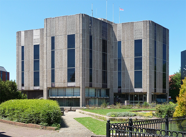
English: The theme here is the hexagon. The plan of the building is six hexagons clustered together in the shape of a hexagon, a further one inside, and one projecting hexagon at the entrance. That makes eight in total, which spoils the six-ness somewhat. The hexagons are of different heights. They are clad in aggregate with narrow, tinted vertical windows. Built as part of a comprehensive civic redevelopment in 1971-76 to the designs of R. Matthew, Johnson-Marshall & Partners.
It is still the HQ of Reading Council. |
| Date | |
| Source | From geograph.org.uk; transferred by User:BaldBoris using geograph_org2commons. |
| Author | Stephen Richards |
| Permission ( Reusing this file) |
Creative Commons Attribution Share-alike license 2.0 |
| Attribution ( required by the license) | Stephen Richards / Civic Centre, Reading / |
| Camera location | | View this and other nearby images on: OpenStreetMap |
|
|---|
| Object location | | View this and other nearby images on: OpenStreetMap |
|
|---|
_region:GB-GBN_heading:270.00&language=en)
Licensing

|
This image was taken from the
Geograph project collection. See
this photograph's page on the Geograph website for the photographer's contact details. The copyright on this image is owned by Stephen Richards and is licensed for reuse under the
Creative Commons Attribution-ShareAlike 2.0 license.
|
This file is licensed under the
Creative Commons
Attribution-Share Alike 2.0 Generic license.
Attribution: Stephen Richards
- You are free:
- to share – to copy, distribute and transmit the work
- to remix – to adapt the work
- Under the following conditions:
- attribution – You must give appropriate credit, provide a link to the license, and indicate if changes were made. You may do so in any reasonable manner, but not in any way that suggests the licensor endorses you or your use.
- share alike – If you remix, transform, or build upon the material, you must distribute your contributions under the same or compatible license as the original.
File history
Click on a date/time to view the file as it appeared at that time.
| Date/Time | Thumbnail | Dimensions | User | Comment | |
|---|---|---|---|---|---|
| current | 00:13, 24 January 2012 |
| 640 × 470 (202 KB) | File Upload Bot (Magnus Manske) |
File usage
The following pages on the English Wikipedia use this file (pages on other projects are not listed):
Global file usage
The following other wikis use this file: