CircumnavigationByCapes.png (800 × 500 pixels, file size: 286 KB, MIME type: image/png)
| This is a file from the
Wikimedia Commons. Information from its
description page there is shown below. Commons is a freely licensed media file repository. You can help. |
Summary
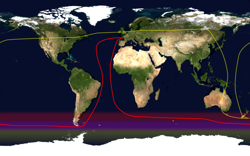
This image shows the route, in red, of a typical round-the-world yacht race via the great capes, by way of the roaring forties. Shown in yellow is the antipodean point of each point on the route; it can be seen that a boat following this route will not pass through any pair of antipodal points. Since doing so in the context of a race — particularly a non-stop race — would be impractical, yacht racing uses a different definition of a circumnavigation.
This image was constructed from a public domain Visible Earth product of the Earth Observatory office of the United States government space agency NASA. It is based on a cylindrical equi-distant projection.
Licensing
| This file is in the public domain in the United States because it was solely created by NASA. NASA copyright policy states that "NASA material is not protected by copyright unless noted". (See Template:PD-USGov, NASA copyright policy page or JPL Image Use Policy.) | ||
 |
Warnings:
|
File history
Click on a date/time to view the file as it appeared at that time.
| Date/Time | Thumbnail | Dimensions | User | Comment | |
|---|---|---|---|---|---|
| current | 16:09, 23 January 2006 |
| 800 × 500 (286 KB) | Johantheghost | This image shows the route, in red, of a typical round-the-world yacht race via the great capes, by way of the roaring forties. Shown in yellow is the [[Wikipedia:antipodes |
File usage
Global file usage
The following other wikis use this file:
- Usage on ast.wikipedia.org
- Usage on es.wikipedia.org
- Usage on fr.wikipedia.org
- Usage on he.wikipedia.org
- Usage on ja.wikipedia.org
- Usage on ko.wikipedia.org
- Usage on la.wikipedia.org
- Usage on nl.wikipedia.org
- Usage on pl.wikipedia.org
- Usage on pt.wikipedia.org
- Usage on uk.wikipedia.org