
Size of this preview:
800 × 600 pixels. Other resolutions:
320 × 240 pixels |
640 × 480 pixels |
1,024 × 768 pixels |
1,280 × 960 pixels |
2,560 × 1,920 pixels |
4,032 × 3,024 pixels.
Original file (4,032 × 3,024 pixels, file size: 3.84 MB, MIME type: image/jpeg)
| This is a file from the
Wikimedia Commons. Information from its
description page there is shown below. Commons is a freely licensed media file repository. You can help. |
Summary
| Description |
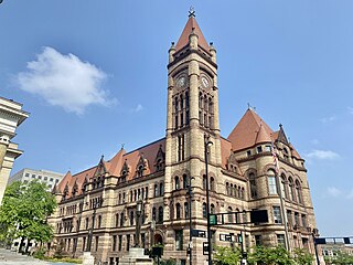
English: This is Cincinnati City Hall, the seat of the municipal government in the city of Cincinnati, located on a block bounded by Plum Street, Central Avenue, 8th Street, and 9th Street at the northwest corner of downtown. Constructed in 1893, the massive Richardson Romanesque-style building was designed by prolific local architect Samuel Hannaford, based on the work of Henry Hobson Richardson, and replaced an earlier, smaller city hall that was constructed on the site in 1852. The building is built of rusticated stone, with a taupe granite base, light tan sandstone body, and darker, red sandstone trim, making up the heavy stone arches and bands, a hallmark of the style. The building utilized forced perspective to make it appear taller and large than it really is, with windows and other features reducing in size higher up on the building. The building has a rough quadrilateral symmetry, only broken by the small details above the doorways and the nine-story tower at the corner of 8th Street and Plum Street, which towers over the surrounding cityscape and features a four-sided clock that can be seen from far afield. The building features many dormers and a complex red slate roof, with conical roofs over the building’s rounded corners and pyramidal roofs over the primary pavilions, which project outwards towards the street from the main body of the building, with the tallest points on the roof being crowned with cast iron finials. Inside, two courtyards allow for light and air to reach interior rooms, while interior spaces are outfitted with fine marble staircases, granite columns, ceiling frescoes stained glass windows, and mosaic floors, all symbols of the city’s 19th Century wealth and prosperity. The fine building is a symbol of the city’s rich past, and continues to serve as the main seat of the city government, having been listed on the National Register of Historic Places in 1972. It sits on Plum Street across from the Issac M. Wise Temple (1866) and next to St. Peter’s-in-Chains Cathedral (1845), two of the city’s most notable landmarks, making this area one of the greatest clusters of 19th Century monumental architecture in the United States. |
| Date | |
| Source | https://www.flickr.com/photos/59081381@N03/53004205204/ |
| Author | w_lemay |
| Camera location | | View this and other nearby images on: OpenStreetMap |
|
|---|
Licensing
This file is licensed under the
Creative Commons
Attribution-Share Alike 2.0 Generic license.
- You are free:
- to share – to copy, distribute and transmit the work
- to remix – to adapt the work
- Under the following conditions:
- attribution – You must give appropriate credit, provide a link to the license, and indicate if changes were made. You may do so in any reasonable manner, but not in any way that suggests the licensor endorses you or your use.
- share alike – If you remix, transform, or build upon the material, you must distribute your contributions under the same or compatible license as the original.
| This image was originally posted to Flickr by w_lemay at https://flickr.com/photos/59081381@N03/53004205204. It was reviewed on 7 August 2023 by FlickreviewR 2 and was confirmed to be licensed under the terms of the cc-by-sa-2.0. |
File history
Click on a date/time to view the file as it appeared at that time.
| Date/Time | Thumbnail | Dimensions | User | Comment | |
|---|---|---|---|---|---|
| current | 13:35, 7 August 2023 |
| 4,032 × 3,024 (3.84 MB) | Ɱ | Uploaded a work by w_lemay from https://www.flickr.com/photos/59081381@N03/53004205204/ with UploadWizard |
File usage
The following pages on the English Wikipedia use this file (pages on other projects are not listed):