Size of this preview:
733 × 599 pixels. Other resolutions:
294 × 240 pixels |
587 × 480 pixels |
939 × 768 pixels |
1,252 × 1,024 pixels |
2,240 × 1,832 pixels.
Original file (2,240 × 1,832 pixels, file size: 1.3 MB, MIME type: image/png)
| This is a file from the
Wikimedia Commons. Information from its
description page there is shown below. Commons is a freely licensed media file repository. You can help. |
Summary
| Description |
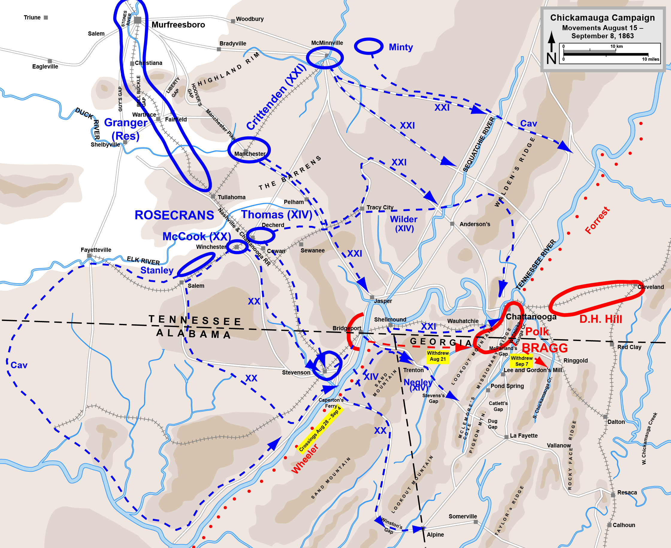
English: Map of
Chickamauga Campaign of the
American Civil War. Drawn in Adobe Illustrator CS5 by Hal Jespersen. Graphic source file is available at
http://www.posix.com/CWmaps/ |
| Date | |
| Source | Own work |
| Author | Hal Jespersen at en.wikipedia |
Licensing
Hal Jespersen at
en.wikipedia, the copyright holder of this work, hereby publishes it under the following license:
This file is licensed under the
Creative Commons
Attribution 3.0 Unported license.
Attribution: Map by Hal Jespersen, www.posix.com/CW
- You are free:
- to share – to copy, distribute and transmit the work
- to remix – to adapt the work
- Under the following conditions:
- attribution – You must give appropriate credit, provide a link to the license, and indicate if changes were made. You may do so in any reasonable manner, but not in any way that suggests the licensor endorses you or your use.
Original upload log
The original description page was
here. All following user names refer to en.wikipedia.
- 2009-03-03 17:15 Hlj 1913×1581× (782992 bytes) Corrected placement of railroad through Sewanee. Same license. {{cc-by-3.0|Map by Hal Jespersen, www.posix.com/CW}}
- 2008-11-02 19:00 Hlj 2000×1653× (3018751 bytes) Oops. Reduce # of pixels.
- 2008-11-02 18:56 Hlj 3985×3294× (1132657 bytes) {{Information |Description=Map of [[Chickamauga Campaign]] of the [[American Civil War]]. Drawn in Adobe Illustrator CS3 by Hal Jespersen. Graphic source file is available at http://www.posix.com/CWmaps/ |Source=own work |Date= November 2, 2008 |Author= H
File history
Click on a date/time to view the file as it appeared at that time.
| Date/Time | Thumbnail | Dimensions | User | Comment | |
|---|---|---|---|---|---|
| current | 18:30, 14 March 2012 |
| 2,240 × 1,832 (1.3 MB) | Hlj | Fixed river course, mountain label. Same license. |
| 00:36, 14 March 2012 |
 | 2,240 × 1,832 (2.14 MB) | Hlj | Fixed a mislabeled city (Ringgold). Updated road and arrow graphics. Same license. | |
| 00:34, 14 March 2012 |
 | 4,479 × 3,663 (3.03 MB) | Hlj | Fixed a mislabeled city (Ringgold). Updated road and arrow graphics. Same license. | |
| 21:46, 30 March 2011 |
 | 2,240 × 1,832 (1.06 MB) | Hlj | Updated graphical formats for rivers and roads. Same license. | |
| 15:01, 24 January 2010 |
 | 1,913 × 1,581 (765 KB) | BotMultichill | {{BotMoveToCommons|en.wikipedia|year={{subst:CURRENTYEAR}}|month={{subst:CURRENTMONTHNAME}}|day={{subst:CURRENTDAY}}}} {{Information |Description={{en|Map of en:Chickamauga Campaign of the en:American Civil War. Drawn in Adobe Illustrator CS |
File usage
The following pages on the English Wikipedia use this file (pages on other projects are not listed):
Global file usage
The following other wikis use this file:
- Usage on azb.wikipedia.org
- Usage on fr.wikipedia.org
- Usage on he.wikipedia.org
- Usage on hu.wikipedia.org
- Usage on it.wikipedia.org
- Usage on nl.wikipedia.org