Size of this preview:
800 × 533 pixels. Other resolutions:
320 × 213 pixels |
640 × 427 pixels |
1,024 × 683 pixels |
1,280 × 853 pixels |
2,560 × 1,707 pixels |
6,000 × 4,000 pixels.
Original file (6,000 × 4,000 pixels, file size: 3.42 MB, MIME type: image/jpeg)
| This is a file from the
Wikimedia Commons. Information from its
description page there is shown below. Commons is a freely licensed media file repository. You can help. |
.jpg)
Summary
| Description |
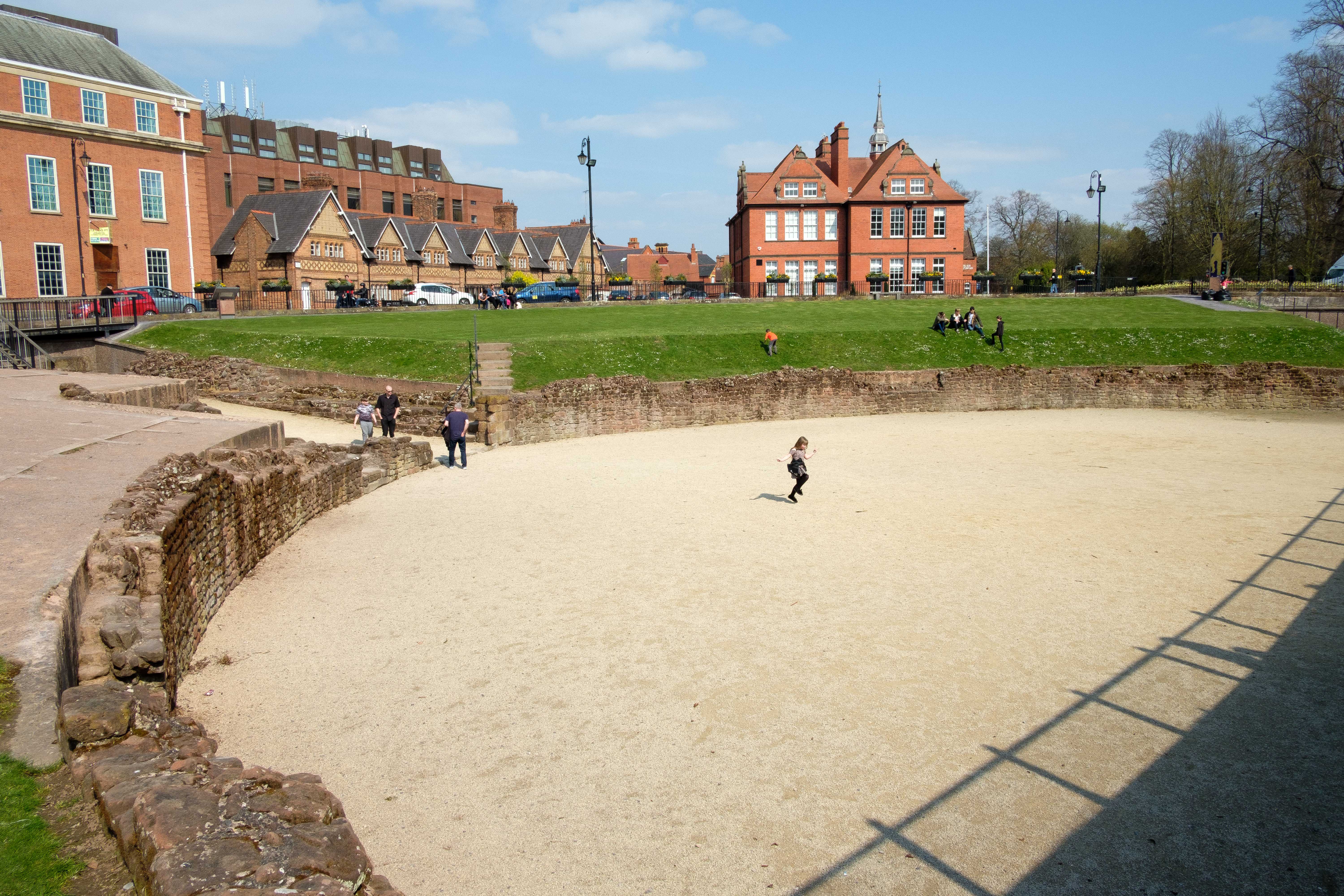
English: Chester's Roman amphitheatre was in use through much of the Roman occupation of Britain, but fell into disuse around the year 350. The amphitheatre was only rediscovered in 1929, when one of the pit walls was discovered during construction work. Between 2000 and 2006, excavation of the amphitheatre took place for Chester City Council and, after 2004, English Heritage. |
| Date | |
| Source | From geograph.org.uk |
| Author | Jeff Buck |
| Permission ( Reusing this file) |
Creative Commons Attribution Share-alike license 2.0 |
| Attribution ( required by the license) | Jeff Buck / Chester Roman Amphitheatre / |
| Camera location | | View this and other nearby images on: OpenStreetMap |
|
|---|
.jpg¶ms=053.189041_N_-002.887294_E_globe:Earth_type:camera_source:geograph-osgb36(SJ40816614)_heading:45.00&language=en)
| Object location | | View this and other nearby images on: OpenStreetMap |
|
|---|
.jpg¶ms=053.189220_N_-002.887150_E_globe:Earth_class:object_type:object_source:geograph-osgb36(SJ40826616)_heading:45.00&language=en)
Licensing

|
This image was taken from the
Geograph project collection. See
this photograph's page on the Geograph website for the photographer's contact details. The copyright on this image is owned by Jeff Buck and is licensed for reuse under the
Creative Commons Attribution-ShareAlike 2.0 license.
|
This file is licensed under the
Creative Commons
Attribution-Share Alike 2.0 Generic license.
Attribution: Jeff Buck
- You are free:
- to share – to copy, distribute and transmit the work
- to remix – to adapt the work
- Under the following conditions:
- attribution – You must give appropriate credit, provide a link to the license, and indicate if changes were made. You may do so in any reasonable manner, but not in any way that suggests the licensor endorses you or your use.
- share alike – If you remix, transform, or build upon the material, you must distribute your contributions under the same or compatible license as the original.
File history
Click on a date/time to view the file as it appeared at that time.
| Date/Time | Thumbnail | Dimensions | User | Comment | |
|---|---|---|---|---|---|
| current | 14:57, 14 July 2023 |
| 6,000 × 4,000 (3.42 MB) | Chocolateediter | == {{int:filedesc}} == {{Information |Description={{en|1= Chester's Roman amphitheatre was in use through much of the Roman occupation of Britain, but fell into disuse around the year 350. The amphitheatre was only rediscovered in 1929, when one of the pit walls was discovered during construction work. Between 2000 and 2006, excavation of the amphitheatre took place for Chester City Council and, after 2004, English Heritage.}} |Source=From [https://www.geograph.org.uk/photo/6376074 geograph.o... |
File usage
The following pages on the English Wikipedia use this file (pages on other projects are not listed):
Global file usage
The following other wikis use this file:
- Usage on ru.wikipedia.org
.jpg)