
Size of this preview:
800 × 548 pixels. Other resolutions:
320 × 219 pixels |
640 × 438 pixels |
1,024 × 701 pixels |
1,280 × 877 pixels |
1,967 × 1,347 pixels.
Original file (1,967 × 1,347 pixels, file size: 859 KB, MIME type: image/jpeg)
| This is a file from the
Wikimedia Commons. Information from its
description page there is shown below. Commons is a freely licensed media file repository. You can help. |
Summary
| Description |
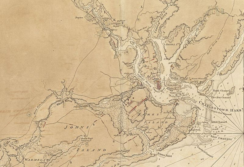
English: This is a detail of the source map, showing the port of Charleston, South Carolina and the coastline to the south as far as Johns Island. It has markings depicting Continental Army defenses set up in anticipation of British attack. The map was probably drawn by British engineers around the time of the 1780
Siege of Charleston. |
||||||
| Date | |||||||
| Source |
From the Boston Public Library Digital Map Collection:
http://maps.bpl.org/details_11098/ |
||||||
| Author | George Sproule | ||||||
| Permission ( Reusing this file) |
|


File history
Click on a date/time to view the file as it appeared at that time.
| Date/Time | Thumbnail | Dimensions | User | Comment | |
|---|---|---|---|---|---|
| current | 13:13, 8 June 2009 |
| 1,967 × 1,347 (859 KB) | Magicpiano | {{Information |Description={{en|1=This is a detail of the source map, showing the port of Charleston, South Carolina and the coastline to the south as far as Johns Island. It has markings depicting Continental Army defenses set up in anticipation of Brit |
File usage
The following pages on the English Wikipedia use this file (pages on other projects are not listed):
Global file usage
The following other wikis use this file:
- Usage on ca.wikipedia.org
- Usage on es.wikipedia.org
- Usage on fr.wikipedia.org
- Usage on he.wikipedia.org
- Usage on ru.wikipedia.org
- Usage on zh.wikipedia.org