
Size of this preview:
800 × 533 pixels. Other resolutions:
320 × 213 pixels |
640 × 427 pixels |
1,024 × 683 pixels |
1,280 × 854 pixels |
2,560 × 1,707 pixels |
6,300 × 4,201 pixels.
Original file (6,300 × 4,201 pixels, file size: 8.71 MB, MIME type: image/png)
| This is a file from the
Wikimedia Commons. Information from its
description page there is shown below. Commons is a freely licensed media file repository. You can help. |
| Description |
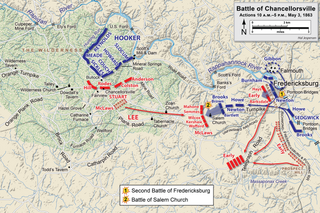
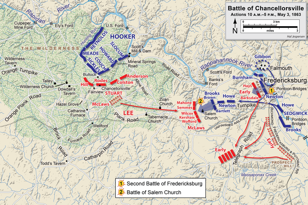
English: Map of a portion (May 3, 10am-5pm) of the battle of Chancellorsville of the
American Civil War. This map partially replaces the map entitled Chancellorsville May3.png.
Drawn in Adobe Illustrator CS6 by Hal Jespersen. Graphic source file is available at http://www.cwmaps.com This file is licensed under the
Creative Commons
Attribution 3.0 Unported license. Attribution: Map by Hal Jespersen, www.cwmaps.com
|
| Date | |
| Source | Own work |
| Author | Hlj |
File history
Click on a date/time to view the file as it appeared at that time.
| Date/Time | Thumbnail | Dimensions | User | Comment | |
|---|---|---|---|---|---|
| current | 18:15, 14 March 2023 |
| 6,300 × 4,201 (8.71 MB) | Hlj | improved graphics |
| 17:52, 30 December 2012 |
 | 2,500 × 1,822 (1.4 MB) | Hlj | Corrected spelling error, made minor graphic improvements | |
| 22:17, 3 June 2011 |
 | 2,500 × 1,822 (1.34 MB) | Hlj | Improved the accuracy of the terrain and some landmarks. Same license. | |
| 19:33, 27 March 2011 |
 | 2,500 × 1,822 (1.3 MB) | Hlj | Update to graphical style of rivers and roads. Same license. | |
| 22:01, 27 January 2011 |
 | 2,500 × 1,822 (1.01 MB) | Hlj | Minor updates to feature labeling and unit positions and actions. {{cc-by-3.0|Map by Hal Jespersen, www.posix.com/CW}} | |
| 00:16, 28 November 2010 |
 | 2,500 × 1,822 (1 MB) | Hlj | {{Information |Description={{en|1=Map of a portion (May 3, 10am-5pm) of the battle of Chancellorsville of the American Civil War. This map partially replaces the map entitled Chancellorsville May3.png. Drawn in Adobe Illustrator CS5 by Hal Jespersen. |
File usage
The following pages on the English Wikipedia use this file (pages on other projects are not listed):
Global file usage
The following other wikis use this file:
- Usage on bg.wikipedia.org
- Usage on es.wikipedia.org
- Usage on fr.wikipedia.org
- Usage on it.wikipedia.org
- Usage on ms.wikipedia.org
- Usage on pt.wikipedia.org
- Usage on ro.wikipedia.org
- Usage on ru.wikipedia.org