
Size of this preview:
800 × 600 pixels. Other resolutions:
320 × 240 pixels |
640 × 480 pixels |
1,024 × 768 pixels |
1,280 × 960 pixels |
2,560 × 1,920 pixels |
3,220 × 2,415 pixels.
Original file (3,220 × 2,415 pixels, file size: 3.56 MB, MIME type: image/jpeg)
| This is a file from the
Wikimedia Commons. Information from its
description page there is shown below. Commons is a freely licensed media file repository. You can help. |
Summary
| Description |
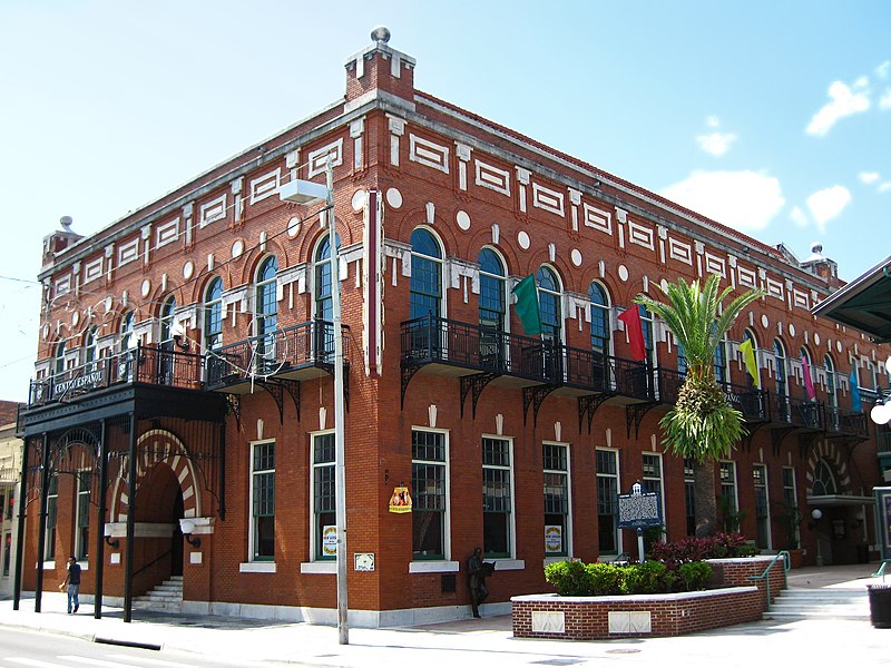
English: El Centro Español de Tampa, a U.S. National Historic Landmark in the Ybor City Historic District of Tampa, Florida. Iron balconies wrap around the east facade to the south facade along 7th Avenue, where they are joined by an iron canopy framing the main entrance.
Español: El Centro Español de Tampa, una Marca Histórica Nacional de los EE.UU., en la Distrito Histórico de Ybor City en Tampa, Florida. Balcones de hierro adornan la fachada del este y la fachada del sur, cerca La Avenida Séptima. Aquí una marquesina de hierro precede a la entrada principal. |
| Date | |
| Source | Own work |
| Author | TampAGS, for AGS Media |
| Camera location | | View this and other nearby images on: OpenStreetMap |
|
|---|
Licensing
I, the copyright holder of this work, hereby publish it under the following licenses:
This file is licensed under the
Creative Commons
Attribution-Share Alike 3.0 Unported license.
- You are free:
- to share – to copy, distribute and transmit the work
- to remix – to adapt the work
- Under the following conditions:
- attribution – You must give appropriate credit, provide a link to the license, and indicate if changes were made. You may do so in any reasonable manner, but not in any way that suggests the licensor endorses you or your use.
- share alike – If you remix, transform, or build upon the material, you must distribute your contributions under the same or compatible license as the original.

|
Permission is granted to copy, distribute and/or modify this document under the terms of the GNU Free Documentation License, Version 1.2 or any later version published by the Free Software Foundation; with no Invariant Sections, no Front-Cover Texts, and no Back-Cover Texts. A copy of the license is included in the section entitled GNU Free Documentation License. |
You may select the license of your choice.
File history
Click on a date/time to view the file as it appeared at that time.
| Date/Time | Thumbnail | Dimensions | User | Comment | |
|---|---|---|---|---|---|
| current | 21:36, 22 May 2010 |
| 3,220 × 2,415 (3.56 MB) | TampAGS | {{Information |Description={{en|1=El Centro Español de Tampa, a U.S. National Historic Landmark in the Ybor City Historic District of Tampa, Florida. Iron balconies wrap around the east facade to the south facade along 7th Avenue, where they are joined |
File usage
The following pages on the English Wikipedia use this file (pages on other projects are not listed):
Global file usage
The following other wikis use this file:
- Usage on de.wikipedia.org
- Usage on es.wikipedia.org
- Usage on fr.wikipedia.org
- Usage on gl.wikipedia.org
- Usage on id.wikipedia.org
- Usage on pl.wikipedia.org
- Usage on www.wikidata.org