Size of this preview:
609 × 600 pixels. Other resolutions:
244 × 240 pixels |
488 × 480 pixels |
780 × 768 pixels |
1,040 × 1,024 pixels |
2,080 × 2,048 pixels |
3,928 × 3,867 pixels.
Original file (3,928 × 3,867 pixels, file size: 4.64 MB, MIME type: image/jpeg)
| This is a file from the
Wikimedia Commons. Information from its
description page there is shown below. Commons is a freely licensed media file repository. You can help. |
Summary
Fonte
Earth.Johnson Space Center.National Aeronautic and Space Administration.government/Space Shuttle Earth Observations Photography/Earth From Space/low resolution.
Central Valley
archive copy at the
Wayback Machine
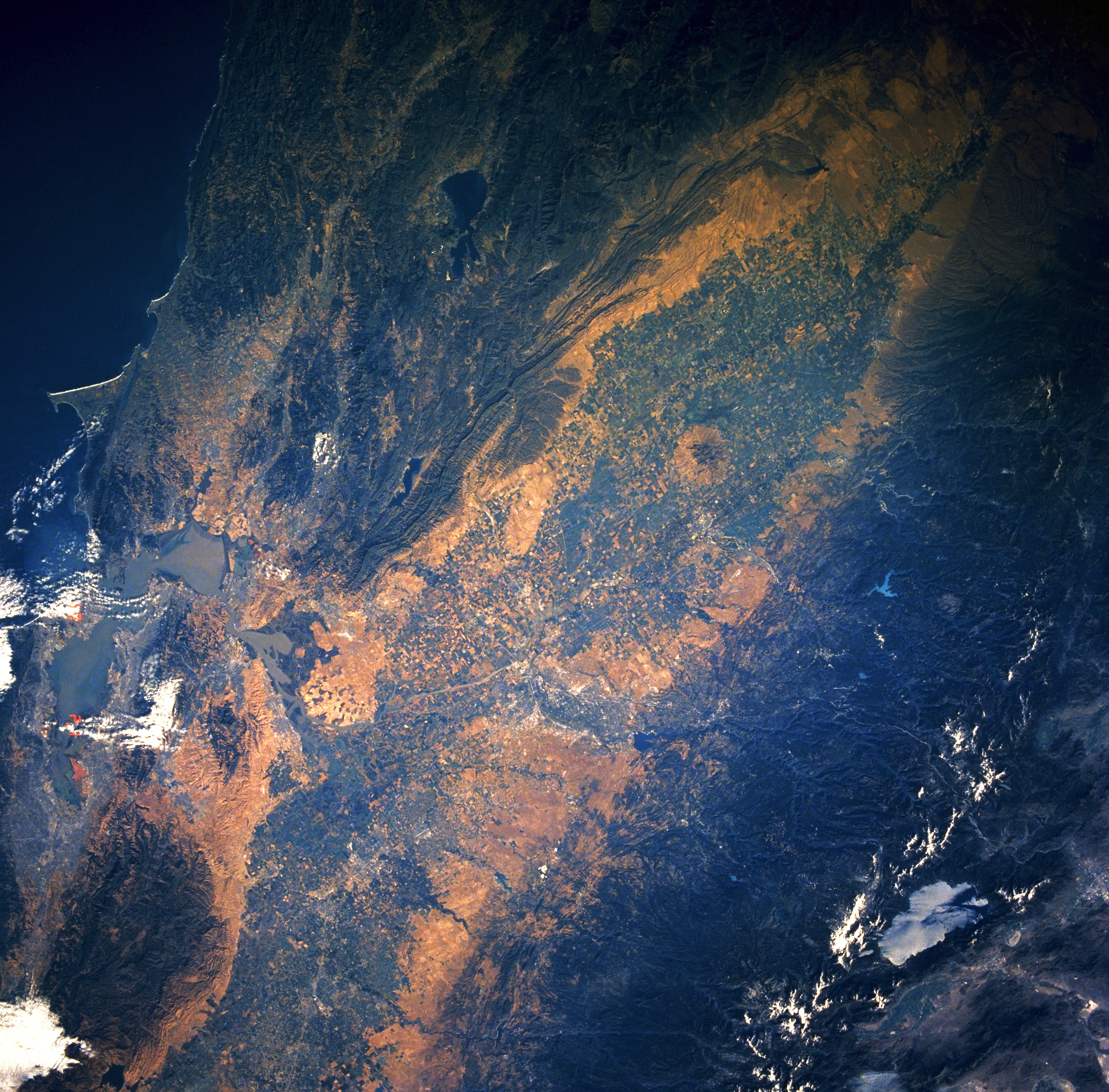
View from Space Shuttle Columbia, mission STS-040, June 1991.
Central Valley, California, June 1991
This low-oblique, southeast-looking, synoptic photograph captures the great Central Valley of California.
- Composed of the Sacramento Valley to the north and the San Joaquin Valley (not pictured in this image) to the south, the Central Valley of California is one of the richest agricultural areas in the United States.
- Visible to the east are the forested slopes and snow-covered higher peaks of the Sierra Nevada Mountains and light blue Lake Tahoe. West of the Central Valley, the Coast Range traverses north-south, and the San Francisco Bay Area is discernible among scattered clouds.
Content Provider
Kamlesh P. Lulla Ph.D. Chief, Earth Sciences Branch
Responsible NASA Official: Ed Wilson
Curator: Jaime Powell
Last Update: 06/17/2002
This image or video was catalogued by one of the centers of the United States
National Aeronautics and Space Administration (NASA) under Photo ID:
STS040-609-38. This tag does not indicate the copyright status of the attached work. A normal copyright tag is still required. See Commons:Licensing. Other languages:
|
Licensing
| This file is in the public domain in the United States because it was solely created by NASA. NASA copyright policy states that "NASA material is not protected by copyright unless noted". (See Template:PD-USGov, NASA copyright policy page or JPL Image Use Policy.) | ||
 |
Warnings:
|
File history
Click on a date/time to view the file as it appeared at that time.
| Date/Time | Thumbnail | Dimensions | User | Comment | |
|---|---|---|---|---|---|
| current | 02:13, 20 November 2011 |
| 3,928 × 3,867 (4.64 MB) | Delirium | actually, here's a bit better version, flipped with N upwards, and brightened somewhat |
| 02:05, 20 November 2011 |
 | 3,928 × 3,867 (10.16 MB) | Delirium | much higher resolution | |
| 09:16, 1 September 2005 |
 | 639 × 630 (73 KB) | Roger469 | == Fonte == Earth.Jonhson Space Center.National Aeronautic and Space Administration.government/Space Shuttle Earth Observations Photography/Earth From Space/low resolution.[ http://earth.jsc.nasa.gov/sseop/efs/lores.pl?PHOTO=STS040-609-38 Central Valley � | |
| 09:12, 1 September 2005 |
 | 639 × 630 (366 KB) | Roger469 | == Fonte == Earth.Jonhson Space Center.National Aeronautic and Space Administration.government/Space Shuttle Earth Observations Photography/Earth From Space/low resolution.[ http://earth.jsc.nasa.gov/sseop/efs/lores.pl?PHOTO=STS040-609-38 Central Valley � |
File usage
The following pages on the English Wikipedia use this file (pages on other projects are not listed):
Global file usage
The following other wikis use this file:
- Usage on ca.wikipedia.org
- Usage on el.wikipedia.org
- Usage on nl.wikipedia.org
- Usage on tr.wikipedia.org
- Usage on vi.wikipedia.org
- Usage on www.wikidata.org