No higher resolution available.
Cataldo_Church.JPG (640 × 426 pixels, file size: 122 KB, MIME type: image/jpeg)
| This is a file from the
Wikimedia Commons. Information from its
description page there is shown below. Commons is a freely licensed media file repository. You can help. |
|
This is an image of a place or building that is listed on the
National Register of Historic Places in the
United States of America. Its reference number is
66000312. |
Summary
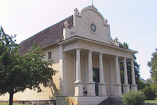
| Description | Sacred Heart Church in Old Mission State Park in Idaho in the United States. Located where the Coeur d'Alene River enters into Lake Coeur d'Alene, the Coeur d'Alene Mission of the Sacred Heart was established in 1843 by the Roman Catholic Church as a Christian missionary outpost. The church was built in 1858, and designed by Father Antonio Ravalli. No nails or metal pieces were used in its construction. The mission later relocated near the modern town of De Smet, Idaho, at which time this structure became known as "Cataldo Mission" or "Old Mission". The structure and outbuildings were added to the U.S. National Register of Historic Places on October 15, 1966. The structure and outbuildings were made a U.S. National Historic Landmark on July 4, 1961. |
| Date | 2 April 2008 (original upload date) |
| Source | Transferred from en.wikipedia |
| Author | Vatsun at en.wikipedia |
| Permission ( Reusing this file) |
Vatsun at
en.wikipedia, the copyright holder of this work, hereby publishes it under the following license: This file is licensed under the
Creative Commons
Attribution 3.0 Unported license. Attribution:
Vatsun at
en.wikipedia
|
| Object location |
| View this and other nearby images on: OpenStreetMap |
|
|---|
Original upload log
The original description page was
here. All following user names refer to en.wikipedia.
- 2008-04-02 02:40 Vatsun 640×426×8 (124778 bytes)
File history
Click on a date/time to view the file as it appeared at that time.
| Date/Time | Thumbnail | Dimensions | User | Comment | |
|---|---|---|---|---|---|
| current | 01:37, 13 May 2008 |
| 640 × 426 (122 KB) | File Upload Bot (Magnus Manske) | {{BotMoveToCommons|en.wikipedia}} {{Information |Description={{en|== Licensing: ==}} |Source=Transferred from [http://en.wikipedia.org en.wikipedia] |Date=2008-04-02 (first version); 2008-04-02 (last version) |Author=Original uploader was [[:en:User:Vats |
File usage
The following pages on the English Wikipedia use this file (pages on other projects are not listed):
Global file usage
The following other wikis use this file:
- Usage on ceb.wikipedia.org
- Usage on en.wikivoyage.org
- Usage on fr.wikipedia.org
- Usage on pt.wikipedia.org
- Usage on www.wikidata.org