
Size of this preview:
800 × 554 pixels. Other resolutions:
320 × 221 pixels |
640 × 443 pixels |
1,024 × 709 pixels |
1,280 × 886 pixels |
2,048 × 1,417 pixels.
Original file (2,048 × 1,417 pixels, file size: 1.5 MB, MIME type: image/jpeg)
| This is a file from the
Wikimedia Commons. Information from its
description page there is shown below. Commons is a freely licensed media file repository. You can help. |
.jpeg)
Summary
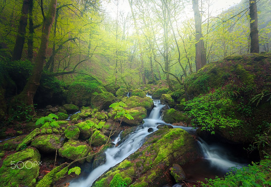
| Caspian Forests | |
|---|---|
| Photographer | |
| Title |
Caspian Forests |
| Description |
500px provided description: "Hyrcanian forests " ' Hyrcanian Forest ' contains remnants (refugia) of the broad leaf forests that once covered most of the North Temperate Zone 25 - 50 million years ago, in the early Cenozoic Era. As the climate and land forms changed, this forest disappeared from most of its former range, being replaced by shrublands, grasslands, and woodlands. During the Pleistocene ("Ice Ages"), glaciations had minimal impact on Hyrcanian Forest. North of Iran as along band has diverse natural, economic and social conditions. Hyrcanian forest contain the most important and significant natural habitats for in-situ conservation of biological diversity, including those containing threatened species of outstanding universal value from the point of view of science or conservation." The Caspian forest "(North of Iran) areas are among the most unique and splendid biomes of the world. The Caspian forests have high moisture content, so forest trees are host to many epiphytes such as mosses, ferns, lichens, mistletoes and some flowering plants. Soils are productive and rich in minerals and organic matter [#landscape ,#fog ,#forest ,#spring ,#nature ,#river ,#tree ,#long exposure ,#fine art ,#iran] |
| Date | 7 April 2017, 17:09:06 |
| Source | Imported from 500px ( archived version) by the Archive Team. ( detail page) |
| Permission ( Reusing this file) |
This file is licensed under the
Creative Commons
Attribution-Share Alike 3.0 Unported license.
|
| Camera location |
| View this and other nearby images on: OpenStreetMap |
|
|---|
.jpeg¶ms=037.280946_N_0049.592413_E_globe:Earth_type:camera__&language=en)
File history
Click on a date/time to view the file as it appeared at that time.
| Date/Time | Thumbnail | Dimensions | User | Comment | |
|---|---|---|---|---|---|
| current | 12:00, 1 November 2019 |
| 2,048 × 1,417 (1.5 MB) | Rodrigo.Argenton | Photo Caspian Forests imported from 500px with import-500px |
File usage
The following pages on the English Wikipedia use this file (pages on other projects are not listed):
Global file usage
The following other wikis use this file:
- Usage on az.wikipedia.org
- Usage on bn.wikipedia.org
- Usage on fa.wikipedia.org
- Usage on ml.wikipedia.org
- Usage on mt.wikipedia.org
- Usage on pt.wikipedia.org
- Usage on sh.wikipedia.org
- Usage on sl.wikipedia.org
.jpeg)