No higher resolution available.
Carysfort-reef-lh.JPG (361 × 314 pixels, file size: 22 KB, MIME type: image/jpeg)
| This is a file from the
Wikimedia Commons. Information from its
description page there is shown below. Commons is a freely licensed media file repository. You can help. |
Summary
|
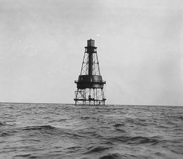
This is an image of a place or building that is listed on the
National Register of Historic Places in the
United States of America. Its reference number is
84000199. |
| Description |
English:
Carysfort Reef Light. Copied from
[1]. No photo number/caption/date; photographer unknown. Ownership disclaimer at
[2] says, "Information presented on this web site is considered public information and may be distributed or copied." |
| Source | US gov |
| Author | US gov |
| Object location |
| View this and other nearby images on: OpenStreetMap |
|
|---|
Licensing
This work is in the
public domain in the United States because it is a
work prepared by an officer or employee of the United States Government as part of that person’s official duties under the terms of
Title 17, Chapter 1, Section 105 of the
US Code.
Note: This only applies to original works of the Federal Government and not to the work of any individual
U.S. state,
territory, commonwealth, county, municipality, or any other subdivision. This template also does not apply to postage stamp designs published by the
United States Postal Service
since 1978. (See §
313.6(C)(1) of Compendium of U.S. Copyright Office Practices). It also does not apply to certain US coins; see
The US Mint Terms of Use.
|
 | |
| This file has been identified as being free of known restrictions under copyright law, including all related and neighboring rights. | ||
Original upload log
The original description page was
here. All following user names refer to en.wikipedia.
- 2005-12-11 12:28 Donald Albury 361×314× (22934 bytes) Copied from [http://www.uscg.mil/hq/g-cp/history/WEBLIGHTHOUSES/LHFL.html]. No photo number/caption/date; photographer unknown. Ownership disclaimer at [http://www.uscg.mil/disclaim.html] says, "Information presented on this web site is considered public
File history
Click on a date/time to view the file as it appeared at that time.
| Date/Time | Thumbnail | Dimensions | User | Comment | |
|---|---|---|---|---|---|
| current | 13:09, 31 October 2009 |
| 361 × 314 (22 KB) | File Upload Bot (Magnus Manske) | {{BotMoveToCommons|en.wikipedia|year={{subst:CURRENTYEAR}}|month={{subst:CURRENTMONTHNAME}}|day={{subst:CURRENTDAY}}}} {{Information |Description={{en|Copied from [http://www.uscg.mil/hq/g-cp/history/WEBLIGHTHOUSES/LHFL.html]. No photo number/caption/dat |
File usage
The following pages on the English Wikipedia use this file (pages on other projects are not listed):
Global file usage
The following other wikis use this file:
- Usage on de.wikipedia.org
- Usage on fr.wikipedia.org
- Usage on www.wikidata.org