Size of this preview:
600 × 600 pixels. Other resolutions:
240 × 240 pixels |
480 × 480 pixels |
720 × 720 pixels.
Original file (720 × 720 pixels, file size: 145 KB, MIME type: image/jpeg)
| This is a file from the
Wikimedia Commons. Information from its
description page there is shown below. Commons is a freely licensed media file repository. You can help. |
Summary
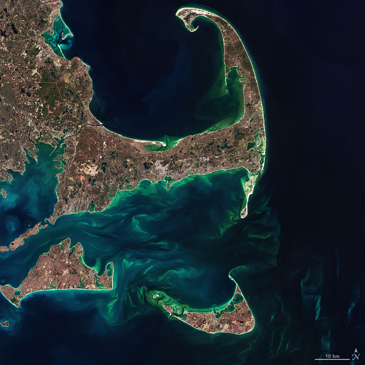
| Description | The image below—a closeup of Cape Cod, Martha’s Vineyard, Nantucket, and the shoals between them—was acquired by the Operational Land Imager (OLI) on the Landsat 8 satellite on February 24, 2020. |
| Date | |
| Source | https://earthobservatory.nasa.gov/images/146412/hints-of-spring-in-the-atlantic |
| Author | NASA Earth Observatory images by Joshua Stevens and Norman Kuring, using Landsat data from the U.S. Geological Survey |
Licensing
| This file is in the public domain in the United States because it was solely created by NASA. NASA copyright policy states that "NASA material is not protected by copyright unless noted". (See Template:PD-USGov, NASA copyright policy page or JPL Image Use Policy.) | ||
 |
Warnings:
|
File history
Click on a date/time to view the file as it appeared at that time.
| Date/Time | Thumbnail | Dimensions | User | Comment | |
|---|---|---|---|---|---|
| current | 03:06, 26 May 2021 |
| 720 × 720 (145 KB) | StellarHalo | {{Information |Description=The image below—a closeup of Cape Cod, Martha’s Vineyard, Nantucket, and the shoals between them—was acquired by the Operational Land Imager (OLI) on the Landsat 8 satellite on February 24, 2020. |Source=https://earthobservatory.nasa.gov/images/146412/hints-of-spring-in-the-atlantic |Date=24 February 2020 |Author=NASA Earth Observatory images by Joshua Stevens and Norman Kuring, using Landsat data from the U.S. Geological Survey |Permission= |other_versions= }} [[Ca... |
File usage
No pages on the English Wikipedia use this file (pages on other projects are not listed).
Global file usage
The following other wikis use this file:
- Usage on af.wikipedia.org