Size of this PNG preview of this TIF file:
800 × 394 pixels. Other resolutions:
320 × 158 pixels |
640 × 316 pixels |
1,024 × 505 pixels |
2,016 × 994 pixels.
Original file (2,016 × 994 pixels, file size: 3.01 MB, MIME type: image/tiff)
| This is a file from the
Wikimedia Commons. Information from its
description page there is shown below. Commons is a freely licensed media file repository. You can help. |
Summary
| Description |
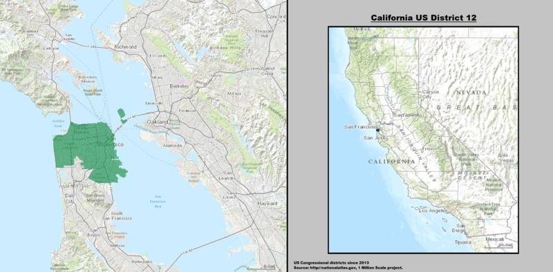
English: Boundaries for
California's 12th US Federal Congressional District — in San Francisco. |
| Date | |
| Source | GIS shapefile data created by the United States Department of the Interior, as part of the "1 Million Scale" geospatial data project. Retrieved from: http://nationalatlas.gov/atlasftp-1m.html?openChapters=#chpbound |
| Author | 1: GIS (congressional districts, 2013) shapefile data was created by the United States Department of the Interior. 2: Data was rendered using ArcGIS® software by Esri. 3: File developed for use on Wikipedia and elsewhere by 7partparadigm. |
Licensing
This map was obtained from an edition of the
National Atlas of the United States. Like almost all works of the U.S. federal government, works from the National Atlas are in the
public domain in the United States.
Online access: NationalAtlas.gov | 1970 print edition: Library of Congress, Perry-Castañeda Library
|
en:California's 12th congressional district
File history
Click on a date/time to view the file as it appeared at that time.
| Date/Time | Thumbnail | Dimensions | User | Comment | |
|---|---|---|---|---|---|
| current | 03:18, 22 March 2014 |
 | 2,016 × 994 (3.01 MB) | 7partparadigm | User created page with UploadWizard |
File usage
The following pages on the English Wikipedia use this file (pages on other projects are not listed):
Global file usage
The following other wikis use this file:
- Usage on es.wikipedia.org
- Usage on fr.wikipedia.org
- Usage on hu.wikipedia.org
- Usage on tr.wikipedia.org
- Usage on www.wikidata.org
- Usage on zh.wikipedia.org