
Size of this PNG preview of this SVG file:
800 × 474 pixels. Other resolutions:
320 × 190 pixels |
640 × 379 pixels |
1,024 × 607 pixels |
1,280 × 758 pixels |
2,560 × 1,517 pixels |
1,028 × 609 pixels.
Original file (SVG file, nominally 1,028 × 609 pixels, file size: 2.97 MB)
| This is a file from the
Wikimedia Commons. Information from its
description page there is shown below. Commons is a freely licensed media file repository. You can help. |
Summary
| Description |
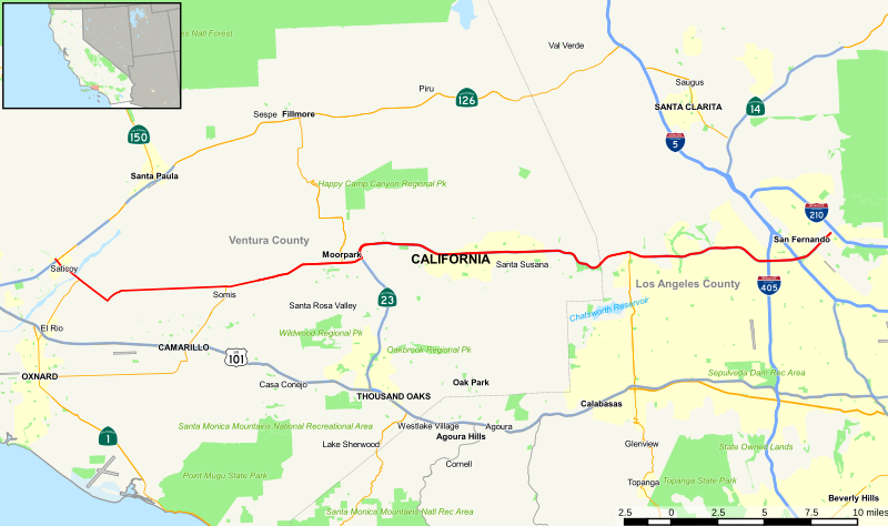
English: Map of California State Route 118 |
| Date | |
| Source | Own work |
| Author | Chinissai |
| SVG development |
Licensing
I, the copyright holder of this work, hereby publish it under the following license:
This file is licensed under the
Creative Commons
Attribution-Share Alike 4.0 International license.
- You are free:
- to share – to copy, distribute and transmit the work
- to remix – to adapt the work
- Under the following conditions:
- attribution – You must give appropriate credit, provide a link to the license, and indicate if changes were made. You may do so in any reasonable manner, but not in any way that suggests the licensor endorses you or your use.
- share alike – If you remix, transform, or build upon the material, you must distribute your contributions under the same or compatible license as the original.
File history
Click on a date/time to view the file as it appeared at that time.
| Date/Time | Thumbnail | Dimensions | User | Comment | |
|---|---|---|---|---|---|
| current | 00:27, 9 November 2015 |
| 1,028 × 609 (2.97 MB) | Chinissai | User created page with UploadWizard |
File usage
No pages on the English Wikipedia use this file (pages on other projects are not listed).
Global file usage
The following other wikis use this file:
- Usage on de.wikipedia.org
- Usage on es.wikipedia.org
- Usage on www.wikidata.org
- Usage on zh-min-nan.wikipedia.org