CUQ_19700101_creation.png (346 × 288 pixels, file size: 5 KB, MIME type: image/png)
Summary
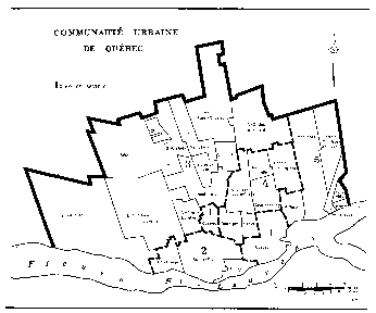
| Description |
Map showing CUQ municipal and sector boundaries at creation (January 1, 1970 |
|---|---|
| Source |
Bureau de la statistique du Québec, ed. (1971). Annuaire du Québec 1971 (in French) (51st ed.). Éditeur officiel du Québec. p. 27. |
| Article | |
| Portion used | |
| Low resolution? |
yes |
| Purpose of use |
Historical perspective, to identify original constituent CUQ municipalities before subsequent amalgamations, annexations and name changes between 1970 and 1983 |
| Replaceable? |
Irreplaceable: map is not available outside cited source |
| Other information |
Published February 1971 |
| Fair use Fair use of copyrighted material in the context of Communauté urbaine de Québec//en.wikipedia.org/wiki/File:CUQ_19700101_creation.pngtrue | |
Licensing
 | This image is a faithful digitisation of a unique historic image, and the copyright for it is most likely held by the person who created the image or the agency employing the person. It is believed that the use of this image may qualify as
non-free use under the
Copyright law of the United States. Any other uses of this image, on Wikipedia or elsewhere, may be
copyright infringement. See
Wikipedia:Non-free content for more information. Please remember that the non-free content criteria require that non-free images on Wikipedia must not "[be] used in a manner that is likely to replace the original market role of the original copyrighted media." Use of historic images from press agencies must only be of a transformative nature, when the image itself is the subject of commentary rather than the event it depicts (which is the original market role, and is not allowed per policy). | ||
| |||
File history
Click on a date/time to view the file as it appeared at that time.
| Date/Time | Thumbnail | Dimensions | User | Comment | |
|---|---|---|---|---|---|
| current | 20:22, 17 January 2017 |
| 346 × 288 (5 KB) | DatBot ( talk | contribs) | Reduce size of non-free image ( BOT - disable) |
| 18:48, 12 January 2017 | No thumbnail | 3,140 × 2,622 (62 KB) | Raellerby ( talk | contribs) | {{Non-free use rationale |Article=Communauté urbaine de Québec |Description=Map showing CUQ municipal and sector boundaries at creation (January 1, 1970 |Source={{cite book|editor = Bureau de la statistique du Québec|title = Annuaire du Québec 1971... |
You cannot overwrite this file.