
Size of this PNG preview of this SVG file:
512 × 317 pixels. Other resolutions:
320 × 198 pixels |
640 × 396 pixels |
1,024 × 634 pixels |
1,280 × 793 pixels |
2,560 × 1,585 pixels.
Original file (SVG file, nominally 512 × 317 pixels, file size: 53 KB)
| This is a file from the
Wikimedia Commons. Information from its
description page there is shown below. Commons is a freely licensed media file repository. You can help. |
.svg)
Summary
| Description |
English:
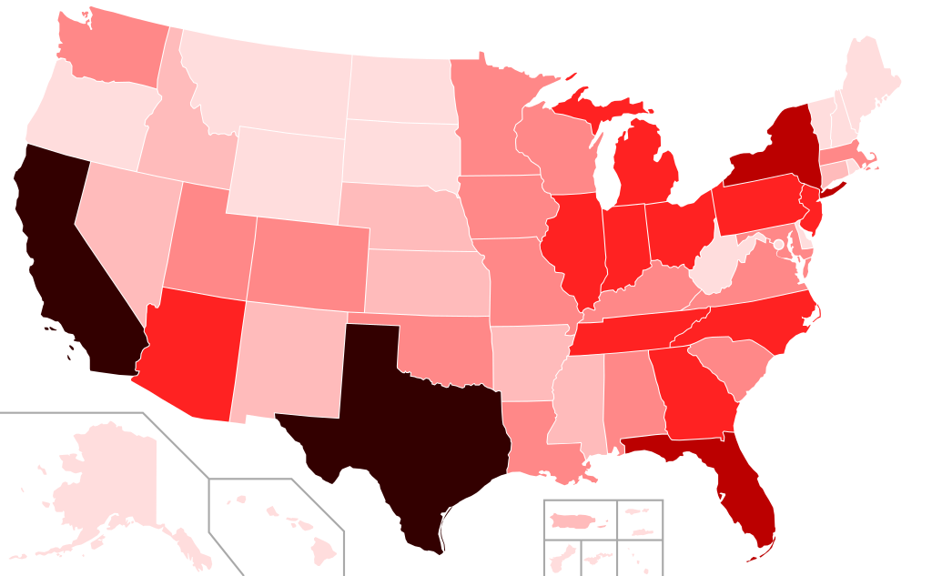
COVID-19 Outbreak Cases in the United States (as of 11 February 2021):
<150,000 confirmed
>150,000 confirmed
>325,000 confirmed
>625,000 confirmed
>1,250,000 confirmed
>2,500,000 confirmed |
| Date | |
| Source | Own work |
| Author | Svenskbygderna ( talk) |
| SVG development |
Licensing
I, the copyright holder of this work, hereby publish it under the following license:
This file is licensed under the
Creative Commons
Attribution-Share Alike 4.0 International license.
- You are free:
- to share – to copy, distribute and transmit the work
- to remix – to adapt the work
- Under the following conditions:
- attribution – You must give appropriate credit, provide a link to the license, and indicate if changes were made. You may do so in any reasonable manner, but not in any way that suggests the licensor endorses you or your use.
- share alike – If you remix, transform, or build upon the material, you must distribute your contributions under the same or compatible license as the original.
File history
Click on a date/time to view the file as it appeared at that time.
.svg&dir=prev)
.svg&offset=20200825032013)
.svg&offset=&limit=20)
.svg&offset=&limit=50)
.svg&offset=&limit=100)
.svg&offset=&limit=250)
.svg&offset=&limit=500)
| Date/Time | Thumbnail | Dimensions | User | Comment | |
|---|---|---|---|---|---|
| current | 20:54, 11 February 2021 |
| 512 × 317 (53 KB) | Aaronw1109 | Update as of 11 February 2021 , 3 PM ET |
| 17:26, 29 November 2020 |
 | 512 × 317 (53 KB) | TheNavigatrr | Update 29 November. | |
| 07:23, 24 November 2020 |
 | 512 × 317 (53 KB) | TheNavigatrr | Updated with latest results. This is basically going to look like a population map. | |
| 20:21, 11 November 2020 |
 | 512 × 317 (53 KB) | Aaronw1109 | update Nov. 11, 2020 | |
| 23:53, 28 October 2020 |
 | 512 × 317 (53 KB) | Aaronw1109 | Update 28 October 2020 | |
| 20:08, 24 September 2020 |
 | 512 × 317 (53 KB) | Aaronw1109 | Update 24 September 2020 | |
| 17:46, 14 September 2020 |
 | 512 × 317 (53 KB) | Aaronw1109 | Update 14 September 2020 | |
| 04:18, 9 September 2020 |
 | 512 × 317 (53 KB) | Aaronw1109 | Update 9 September 2020, 12 AM ET | |
| 02:08, 30 August 2020 |
 | 512 × 317 (53 KB) | Aaronw1109 | update new mexico. 30 august 2020 12am et | |
| 03:20, 25 August 2020 |
 | 512 × 317 (53 KB) | Aaronw1109 | Update 25 August 2020, 12 AM ET |
File usage
The following pages on the English Wikipedia use this file (pages on other projects are not listed):
Global file usage
The following other wikis use this file:
- Usage on ar.wikipedia.org
- Usage on az.wikipedia.org
- Usage on bg.wikipedia.org
- Usage on bn.wikipedia.org
- Usage on ca.wikipedia.org
- Usage on de.wikipedia.org
- Usage on es.wikipedia.org
- Usage on fa.wikipedia.org
- Usage on fr.wikipedia.org
- Usage on he.wikipedia.org
- Usage on ht.wikipedia.org
- Usage on hu.wikipedia.org
- Usage on jv.wikipedia.org
- Usage on ko.wikipedia.org
- Usage on lv.wikipedia.org
- Usage on ms.wikipedia.org
- Usage on nl.wikipedia.org
- Usage on pt.wikipedia.org
- Usage on ro.wikipedia.org
- Usage on ru.wikipedia.org
- Usage on su.wikipedia.org
- Usage on ta.wikipedia.org
- Usage on test.wikipedia.org
- Usage on th.wikipedia.org
- Usage on uk.wikipedia.org
- Usage on vi.wikipedia.org
- Usage on www.wikidata.org
- Usage on zh-yue.wikipedia.org
.svg)