
Size of this preview:
800 × 450 pixels. Other resolutions:
320 × 180 pixels |
640 × 360 pixels |
1,024 × 576 pixels |
1,280 × 720 pixels |
2,560 × 1,440 pixels |
3,712 × 2,088 pixels.
Original file (3,712 × 2,088 pixels, file size: 3.24 MB, MIME type: image/jpeg)
| This is a file from the
Wikimedia Commons. Information from its
description page there is shown below. Commons is a freely licensed media file repository. You can help. |
Summary
| Description |
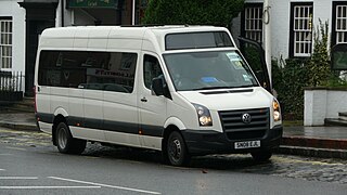
English: Buses 4U SN08 EJL, a
Volkswagen Crafter, in Dorking High Street,
Dorking,
Surrey. It is on the Tuesdays and Fridays only 1205 departure of route 433 from Dorking White Horse to Ockley Cricketers, where it changes into a route 50 and continues to Horsham (with through fares available). This would presumably explain why the bus was showing "50 to Horsham" on the front (just about visible in the windscreen), even though it was actually on route 433. Being rural services, the service provided by routes 50 and 433 is very confusing, with a plentiful supply of timetable variations and different routing on different days, which might explain why the driver had the wrong display on show. |
| Date | |
| Source | Own work |
| Author | Arriva436 |
| Camera location |
| View this and other nearby images on: OpenStreetMap |
|
|---|
Licensing
I, the copyright holder of this work, hereby publish it under the following licenses:

|
Permission is granted to copy, distribute and/or modify this document under the terms of the GNU Free Documentation License, Version 1.2 or any later version published by the Free Software Foundation; with no Invariant Sections, no Front-Cover Texts, and no Back-Cover Texts. A copy of the license is included in the section entitled GNU Free Documentation License. |
This file is licensed under the
Creative Commons
Attribution 3.0 Unported license.
- You are free:
- to share – to copy, distribute and transmit the work
- to remix – to adapt the work
- Under the following conditions:
- attribution – You must give appropriate credit, provide a link to the license, and indicate if changes were made. You may do so in any reasonable manner, but not in any way that suggests the licensor endorses you or your use.
You may select the license of your choice.
File history
Click on a date/time to view the file as it appeared at that time.
| Date/Time | Thumbnail | Dimensions | User | Comment | |
|---|---|---|---|---|---|
| current | 20:29, 14 February 2011 |
| 3,712 × 2,088 (3.24 MB) | Arriva436 |
File usage
The following pages on the English Wikipedia use this file (pages on other projects are not listed):
Global file usage
The following other wikis use this file:
- Usage on af.wikipedia.org
- Usage on bn.wikipedia.org