
Size of this preview:
342 × 599 pixels. Other resolutions:
137 × 240 pixels |
274 × 480 pixels |
438 × 768 pixels |
584 × 1,024 pixels |
1,516 × 2,657 pixels.
Original file (1,516 × 2,657 pixels, file size: 461 KB, MIME type: image/jpeg)
| This is a file from the
Wikimedia Commons. Information from its
description page there is shown below. Commons is a freely licensed media file repository. You can help. |
Summary
| Description |
English:
ไทย:
|
| Date | |
| Source |
Own work
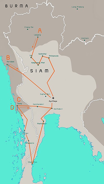
Terwiel, Bertrand. Thailand's Political History: From the 13th Century to Recent Times. Approximate boundaries of the six states that formed after Ayutthaya's destruction. |
| Author | Aristitleism |
| Other versions |
_map_-_TH_-_002.jpg) |
Licensing
I, the copyright holder of this work, hereby publish it under the following license:
| This file is made available under the Creative Commons CC0 1.0 Universal Public Domain Dedication. | |
| The person who associated a work with this deed has dedicated the work to the
public domain by waiving all of their rights to the work worldwide under copyright law, including all related and neighboring rights, to the extent allowed by law. You can copy, modify, distribute and perform the work, even for commercial purposes, all without asking permission.
|
en:Burmese–Siamese War (1765–1767)

|
This historical map image could be re-created using
vector graphics as an
SVG file. This has several advantages; see
Commons:Media for cleanup for more information. If an SVG form of this image is available, please upload it and afterwards replace this template with
{{
vector version available|new image name}}
.
It is recommended to name the SVG file “Burmese-Siamese war (1765-1767) map - EN - 001.svg”—then the template Vector version available (or Vva) does not need the new image name parameter. |


_map_-_EN_-_001.jpg)
File history
Click on a date/time to view the file as it appeared at that time.
_map_-_EN_-_001.jpg&dir=prev)
_map_-_EN_-_001.jpg&offset=20110724171301)
_map_-_EN_-_001.jpg&offset=&limit=20)
_map_-_EN_-_001.jpg&offset=&limit=50)
_map_-_EN_-_001.jpg&offset=&limit=100)
_map_-_EN_-_001.jpg&offset=&limit=250)
_map_-_EN_-_001.jpg&offset=&limit=500)
| Date/Time | Thumbnail | Dimensions | User | Comment | |
|---|---|---|---|---|---|
| current | 08:29, 19 July 2023 |
| 1,516 × 2,657 (461 KB) | Yourlocallordandsavior | Based off the Siamese civil war borders from Terwiel's "Thailand's Political History: From the 13th Century to Recent Times". |
| 08:51, 12 July 2023 |
 | 1,516 × 2,657 (464 KB) | Yourlocallordandsavior | Major updated borders (riverine and land). | |
| 03:40, 3 March 2023 |
 | 1,516 × 2,657 (402 KB) | Yourlocallordandsavior | Added Phetchabun according to 17th century urban places map in "A History of Ayutthaya" by Baker and Phongpaichit. | |
| 04:45, 19 February 2023 |
 | 1,516 × 2,657 (403 KB) | Yourlocallordandsavior | Added Phimai, Phimai was where Prince Thepphiphit had his seat of power in the 1767-71 civil war. | |
| 02:46, 19 February 2023 |
 | 1,516 × 2,657 (404 KB) | Yourlocallordandsavior | . | |
| 01:27, 19 February 2023 |
 | 1,516 × 2,657 (406 KB) | Yourlocallordandsavior | Removed the Forest Mueang and adjusted borders. | |
| 17:23, 19 August 2011 |
 | 1,516 × 2,657 (1.05 MB) | Tiemianwusi | Changing the colour of the third territories (from pale blue to pale taupe) | |
| 15:47, 19 August 2011 |
 | 1,516 × 2,657 (1.05 MB) | Tiemianwusi | (1) Correcting boundaries, (2) Darker Burmese territories, (3) Recolouring third territories, (4) Correcting advance routes. | |
| 08:47, 25 July 2011 |
 | 1,516 × 2,657 (1.05 MB) | Tiemianwusi | "Margui" → "Mergui" | |
| 17:13, 24 July 2011 |
 | 1,516 × 2,657 (1.05 MB) | Tiemianwusi | Correcting territories |
File usage
The following pages on the English Wikipedia use this file (pages on other projects are not listed):
Global file usage
The following other wikis use this file:
- Usage on ar.wikipedia.org
- Usage on es.wikipedia.org
- Usage on it.wikipedia.org
- Usage on km.wikipedia.org
- Usage on my.wikipedia.org
- Usage on uk.wikipedia.org
- Usage on vi.wikipedia.org
- Usage on www.wikidata.org
- Usage on zh.wikipedia.org
_map_-_EN_-_001.jpg)