
Size of this preview:
800 × 387 pixels. Other resolutions:
320 × 155 pixels |
640 × 310 pixels |
1,024 × 495 pixels |
1,280 × 619 pixels |
4,032 × 1,951 pixels.
Original file (4,032 × 1,951 pixels, file size: 2.06 MB, MIME type: image/jpeg)
| This is a file from the
Wikimedia Commons. Information from its
description page there is shown below. Commons is a freely licensed media file repository. You can help. |
Summary
| Description |
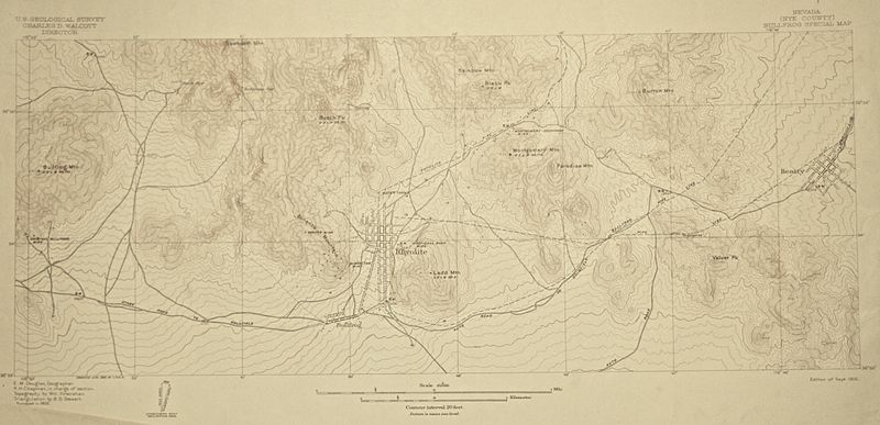
English: 1:24,000 scale map of Rhyolite surveyed in 1905 |
| Date | |
| Source | US Geological Survey |
| Author | Unknown author |
| Camera location |
| View this and other nearby images on: OpenStreetMap |
|
|---|
Licensing
This media file is in the
public domain in the
United States. This applies to U.S. works where the copyright has expired, often because its first
publication occurred prior to January 1, 1929, and if not then due to lack of notice or renewal. See
this page for further explanation.
|
 | |
 |
This image might not be in the public domain outside of the United States; this especially applies in the countries and areas that do not apply the
rule of the shorter term for US works, such as Canada, Mainland China (not Hong Kong or Macao), Germany, Mexico, and Switzerland. The creator and year of publication are essential information and must be provided. See
Wikipedia:Public domain and
Wikipedia:Copyrights for more details.
|
File history
Click on a date/time to view the file as it appeared at that time.
| Date/Time | Thumbnail | Dimensions | User | Comment | |
|---|---|---|---|---|---|
| current | 03:51, 12 February 2015 |
| 4,032 × 1,951 (2.06 MB) | FAHansson | User created page with UploadWizard |
File usage
The following pages on the English Wikipedia use this file (pages on other projects are not listed):