This is a file from the Wikimedia Commons
From Wikipedia, the free encyclopedia

Original file(1,291 × 779 pixels, file size: 93 KB, MIME type: image/jpeg)

Summary

Description
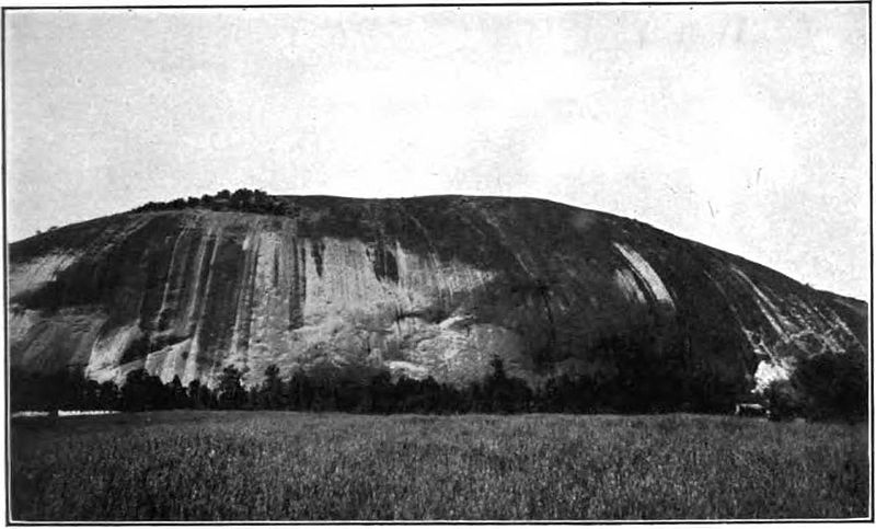
English: Plate XXV A, Original caption: " Stone Mountain, a granite dome, DeKalb County, GA."

This was published in 1910, prior to the construction of the Confederate Memorial.
Text from the volume referring to this figure:
Stone Mountain, which is a huge doming ridge of granite (Pl. XXV, A), is situated about 16 miles east of Atlanta in DeKalb County. It is an elliptical boss, with its longer axis trending northeast and southwest and its steepest side facing northward. It rises 686 feet above the adjacent lowland plain of crystalline rocks, and measures 7 miles in circumference around its base. The present ridge is the unreduced remnant of a much larger granite mass. The evidence favoring this conclusion is the fact that a belt of the same granite reduced to the general level of the surrounding Tertiary Piedmont plain skirts the north, west, and south sides of the ridge with a width varying from a quarter of a mile to more than a mile. The granite of Stone Mountain and the granite gneiss of the adjacent Lithonia area in the same county have had the widest distribution and are the best known of the Georgia granites outside of the State. From the time of their first opening, prior to the civil war, to within the last few years the quarrying of stone in these two areas formed practically the whole granite industry in Georgia. These are the largest granite quarries in Georgia and they yield a much larger output than any other areas in the State.

Numerous quarries yielding an excellent light-gray granite are worked along the western and southern flanks of the ridge. (See Pl. XXV, B.) The stone has been used most extensively for general building purposes, and almost as largely for street material in the form of blocks and curbing. Its very light color makes it undesirable for monument stock. It has been marketed in the principal towns and cities in the South and West.
Date
Source Granites of the Southeastern Atlantic States, Bulletin 426, United States Geological Survey, Government Printing Office, Washington, 1910.
Author Watson, Thomas Leonard

Licensing

Public domain
This image is in the public domain in the United States because it only contains materials that originally came from the United States Geological Survey, an agency of the United States Department of the Interior. For more information, see the official USGS copyright policy.

Bahasa Indonesia  català  čeština  Deutsch  eesti  English  español  français  galego  italiano  Nederlands  português  polski  sicilianu  suomi  Tiếng Việt  Türkçe  български  македонски  русский  മലയാളം  한국어  日本語  中文  中文(简体)  中文(繁體)  العربية  فارسی  +/−

Information

Captions

Add a one-line explanation of what this file represents

Items portrayed in this file

depicts

image/jpeg

535f3b8247216e154ec4c553bf01b4856ec38c86

95,694 byte

779 pixel

1,291 pixel

File history

Click on a date/time to view the file as it appeared at that time.

Date/TimeThumbnailDimensionsUserComment
current 11:40, 26 April 2016 Thumbnail for version as of 11:40, 26 April 20161,291 × 779 (93 KB)JstubyUser created page with UploadWizard
The following pages on the English Wikipedia use this file (pages on other projects are not listed):

Global file usage

The following other wikis use this file: