No higher resolution available.
Broken-down_train_at_Ballyrobert_-_geograph.org.uk_-_1021197.jpg (640 × 384 pixels, file size: 79 KB, MIME type: image/jpeg)
| This is a file from the
Wikimedia Commons. Information from its
description page there is shown below. Commons is a freely licensed media file repository. You can help. |
Summary
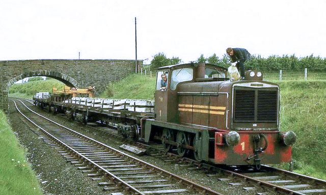
| Description | Broken-down train at Ballyrobert – Northern Ireland Railways had three diesel-hydraulic locomotives used mainly on permanent-way trains. They were prone to overheating. The driver is topping up No. 1’s radiator from an emergency supply of water carried on board. |
| Date | |
| Source | From geograph.org.uk; transferred by User:oxyman using geograph_org2commons. |
| Author | Aubrey Dale |
| Permission ( Reusing this file) |
Creative Commons Attribution Share-alike license 2.0 |
| Attribution ( required by the license) | Aubrey Dale / Broken-down train at Ballyrobert / |
| Camera location | | View this and other nearby images on: OpenStreetMap |
|
|---|
| Object location | | View this and other nearby images on: OpenStreetMap |
|
|---|
_region:GB-NIR_heading:337.00&language=en)
Licensing

|
This image was taken from the
Geograph project collection. See
this photograph's page on the Geograph website for the photographer's contact details. The copyright on this image is owned by Aubrey Dale and is licensed for reuse under the
Creative Commons Attribution-ShareAlike 2.0 license.
|
This file is licensed under the
Creative Commons
Attribution-Share Alike 2.0 Generic license.
Attribution: Aubrey Dale
- You are free:
- to share – to copy, distribute and transmit the work
- to remix – to adapt the work
- Under the following conditions:
- attribution – You must give appropriate credit, provide a link to the license, and indicate if changes were made. You may do so in any reasonable manner, but not in any way that suggests the licensor endorses you or your use.
- share alike – If you remix, transform, or build upon the material, you must distribute your contributions under the same or compatible license as the original.
File history
Click on a date/time to view the file as it appeared at that time.
| Date/Time | Thumbnail | Dimensions | User | Comment | |
|---|---|---|---|---|---|
| current | 11:36, 18 April 2014 |
| 640 × 384 (79 KB) | Bleakcomb | Correct image. Colour. |
| 16:22, 11 November 2009 |
 | 640 × 384 (75 KB) | File Upload Bot (Magnus Manske) | == Summary == {{Information |Description=Broken-down train at Ballyrobert |Source=From [http://www.geograph.org.uk/photo/1021197 geograph.org.uk]; transferd by User:oxyman using [http://toolserver.org/~magnus/geograph_org2commons.php geograph_org2comm |
File usage
The following pages on the English Wikipedia use this file (pages on other projects are not listed):
Global file usage
The following other wikis use this file:
- Usage on fr.wikipedia.org
- Usage on ga.wikipedia.org
- Usage on ru.wikipedia.org
- Usage on www.wikidata.org