
Size of this preview:
800 × 472 pixels. Other resolutions:
320 × 189 pixels |
640 × 378 pixels |
1,024 × 604 pixels |
1,280 × 755 pixels |
2,417 × 1,426 pixels.
Original file (2,417 × 1,426 pixels, file size: 1.51 MB, MIME type: image/jpeg)
| This is a file from the
Wikimedia Commons. Information from its
description page there is shown below. Commons is a freely licensed media file repository. You can help. |
Summary
| Description |
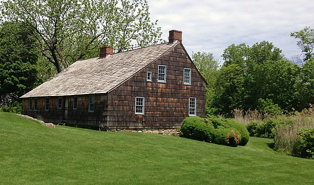
English: The Brewster House in Setauket, New York. The structure dates to 1665 and is the oldest house in the Town of Brookhaven. |
| Date | Taken on 24 May 2014 |
| Source | Own work. |
| Author | Iracaz |
| Object location |
| View this and other nearby images on: OpenStreetMap |
|
|---|
Licensing
Iracaz at
English Wikipedia, the copyright holder of this work, hereby publishes it under the following licenses:

|
Permission is granted to copy, distribute and/or modify this document under the terms of the GNU Free Documentation License, Version 1.2 or any later version published by the Free Software Foundation; with no Invariant Sections, no Front-Cover Texts, and no Back-Cover Texts. A copy of the license is included in the section entitled GNU Free Documentation License. |
This file is licensed under the
Creative Commons
Attribution-Share Alike 3.0 Unported license.
Attribution:
Iracaz at
English Wikipedia
- You are free:
- to share – to copy, distribute and transmit the work
- to remix – to adapt the work
- Under the following conditions:
- attribution – You must give appropriate credit, provide a link to the license, and indicate if changes were made. You may do so in any reasonable manner, but not in any way that suggests the licensor endorses you or your use.
- share alike – If you remix, transform, or build upon the material, you must distribute your contributions under the same or compatible license as the original.
You may select the license of your choice.
Original upload log
The original description page was
here. All following user names refer to en.wikipedia.
| Date/Time | Dimensions | User | Comment |
|---|---|---|---|
| 2014-05-25 15:24 | 2417×1426× (1582817 bytes) | Iracaz | Uploading a self-made file using [[Wikipedia:File_Upload_Wizard|File Upload Wizard]] |
File history
Click on a date/time to view the file as it appeared at that time.
| Date/Time | Thumbnail | Dimensions | User | Comment | |
|---|---|---|---|---|---|
| current | 21:22, 9 November 2014 |
| 2,417 × 1,426 (1.51 MB) | Finavon | Transferred from en.wikipedia |
File usage
The following pages on the English Wikipedia use this file (pages on other projects are not listed):
Global file usage
The following other wikis use this file:
- Usage on ceb.wikipedia.org
- Usage on fr.wikipedia.org
- Usage on lld.wikipedia.org
- Usage on www.wikidata.org