
Size of this preview:
449 × 599 pixels. Other resolutions:
180 × 240 pixels |
360 × 480 pixels |
576 × 768 pixels |
768 × 1,024 pixels |
2,000 × 2,667 pixels.
Original file (2,000 × 2,667 pixels, file size: 1.81 MB, MIME type: image/png)
| This is a file from the
Wikimedia Commons. Information from its
description page there is shown below. Commons is a freely licensed media file repository. You can help. |
Summary
| Description |
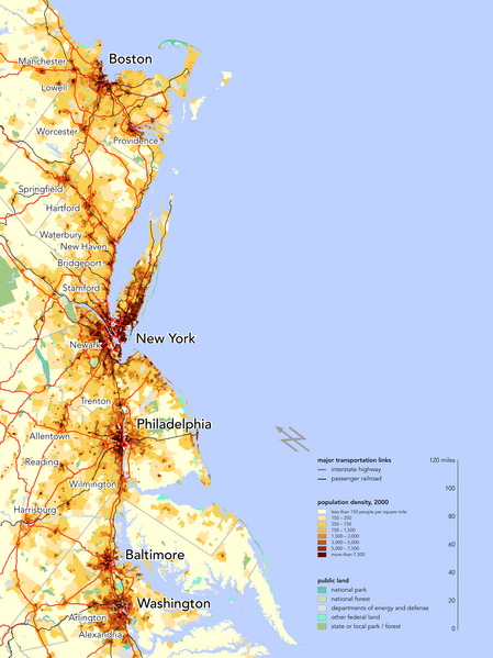
English: Population-density map of the
Northeast megalopolis, also knows as Boston–Washington megalopolis or BosWash. |
| Date | |
| Source | Own work |
| Author | Bill Rankin — Citynoise ( talk · contribs) |
| Permission ( Reusing this file) |
Licensing
I, the copyright holder of this work, hereby publish it under the following license:
This file is licensed under the
Creative Commons
Attribution-Share Alike 3.0 Unported license.
- You are free:
- to share – to copy, distribute and transmit the work
- to remix – to adapt the work
- Under the following conditions:
- attribution – You must give appropriate credit, provide a link to the license, and indicate if changes were made. You may do so in any reasonable manner, but not in any way that suggests the licensor endorses you or your use.
- share alike – If you remix, transform, or build upon the material, you must distribute your contributions under the same or compatible license as the original.
File history
Click on a date/time to view the file as it appeared at that time.
| Date/Time | Thumbnail | Dimensions | User | Comment | |
|---|---|---|---|---|---|
| current | 21:35, 23 October 2022 |
| 2,000 × 2,667 (1.81 MB) | Daniel FR | added north pointer, no further alterations |
| 16:43, 8 December 2010 |
 | 2,000 × 2,667 (1.8 MB) | Citynoise | fixed typo! | |
| 13:42, 29 October 2009 |
 | 2,000 × 2,667 (2.01 MB) | Citynoise | {{Information |Description={{en|1=Population-density Map of BosWash}} |Source={{own}} |Author= Citynoise |Date=2009-05 |Permission= |other_versions= }} This is a special edition of [http://www.radicalcartography.net/?mega] designed for W |
File usage
The following pages on the English Wikipedia use this file (pages on other projects are not listed):
Global file usage
The following other wikis use this file:
- Usage on ar.wikipedia.org
- Usage on ast.wikipedia.org
- Usage on azb.wikipedia.org
- Usage on cs.wikipedia.org
- Usage on da.wikipedia.org
- Usage on de.wikipedia.org
- Usage on eo.wikipedia.org
- Usage on es.wikipedia.org
- Usage on et.wikipedia.org
- Usage on fa.wikipedia.org
- Usage on fi.wikipedia.org
- Usage on fr.wikipedia.org
- Usage on fr.wiktionary.org
- Usage on he.wikipedia.org
- Usage on it.wikipedia.org
- Usage on ja.wikipedia.org
- Usage on la.wikipedia.org
- Usage on nl.wikipedia.org
- Usage on pl.wikipedia.org
- Usage on pt.wikipedia.org
- Usage on ro.wikipedia.org
- Usage on ru.wikipedia.org
- Usage on sk.wikipedia.org
- Usage on sl.wikipedia.org
- Usage on tr.wikipedia.org
- Usage on uk.wikipedia.org
- Usage on ur.wikipedia.org
- Usage on vi.wikipedia.org
- Usage on www.wikidata.org
- Usage on xmf.wikipedia.org
- Usage on zh.wikipedia.org