Size of this preview:
564 × 599 pixels. Other resolutions:
226 × 240 pixels |
452 × 480 pixels |
706 × 750 pixels.
Original file (706 × 750 pixels, file size: 54 KB, MIME type: image/png)
| This is a file from the
Wikimedia Commons. Information from its
description page there is shown below. Commons is a freely licensed media file repository. You can help. |
Summary
| Description |
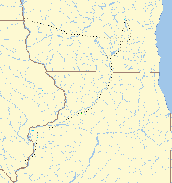
English: Black Hawk's path during the Black Hawk War (1832), showing parts of Illinois, Wisconsin, Iowa, and Illinois. |
| Date | 6 September 2007 (original upload date) |
| Source | Transferred from en.wikipedia to Commons. Map made by User:Ruhrfisch based on US Census maps from [1]. Path added to map by User:Kevin Myers |
| Author | Ruhrfisch at English Wikipedia |
Licensing
Ruhrfisch at the
English Wikipedia, the copyright holder of this work, hereby publishes it under the following license:

|
Permission is granted to copy, distribute and/or modify this document under the terms of the GNU Free Documentation License, Version 1.2 or any later version published by the Free Software Foundation; with no Invariant Sections, no Front-Cover Texts, and no Back-Cover Texts. A copy of the license is included in the section entitled GNU Free Documentation License. |
| This file is licensed under the Creative Commons Attribution-Share Alike 3.0 Unported license. | ||
| Attribution: Ruhrfisch at the English Wikipedia | ||
| ||
| This licensing tag was added to this file as part of the GFDL licensing update. |
Original upload log
The original description page was
here. All following user names refer to en.wikipedia.
- 2011-04-14 05:28 Kevin Myers 706×750× (55743 bytes) Indicate Black Hawk's path.
- 2007-12-02 23:14 Ruhrfisch 706×750× (55712 bytes) Fixed Mississippi border in two places, all other info the same
- 2007-12-02 22:58 Ruhrfisch 706×750× (55494 bytes) Fixed colors, all other information the same
- 2007-09-06 15:43 Ruhrfisch 706×750× (57602 bytes) == Summary == Base Map of the 1832 Black Hawk War, showing parts of Illinois, Wisconsin, Iowa, and Illinois. Made by [[User:Ruhrfisch]] based on US Census maps from [http://factfinder.census.gov]. Cropped version with red X to show Bad Axe battle site O
File history
Click on a date/time to view the file as it appeared at that time.
| Date/Time | Thumbnail | Dimensions | User | Comment | |
|---|---|---|---|---|---|
| current | 02:22, 30 November 2011 |
| 706 × 750 (54 KB) | OgreBot | (BOT): Reverting to most recent version before archival |
| 02:22, 30 November 2011 |
 | 706 × 750 (54 KB) | OgreBot | (BOT): Uploading old version of file from en.wikipedia; originally uploaded on 2007-12-02 23:14:52 by Ruhrfisch | |
| 02:21, 30 November 2011 |
 | 706 × 750 (54 KB) | OgreBot | (BOT): Uploading old version of file from en.wikipedia; originally uploaded on 2007-12-02 22:58:12 by Ruhrfisch | |
| 02:21, 30 November 2011 |
 | 706 × 750 (56 KB) | OgreBot | (BOT): Uploading old version of file from en.wikipedia; originally uploaded on 2007-09-06 15:43:56 by Ruhrfisch | |
| 05:25, 14 April 2011 |
 | 706 × 750 (54 KB) | Kevin1776 | {{Information |Description ={{en|1=Black Hawk's path during the Black Hawk War.}} |Source =Wikipedia |Author =User:Ruhrfisch |Date = |Permission = |other_versions = }} |
File usage
The following pages on the English Wikipedia use this file (pages on other projects are not listed):
- Abraham Lincoln in the Black Hawk War
- Apple River Fort
- Attack at Ament's Cabin
- Attacks at Fort Blue Mounds
- Battle of Apple River Fort
- Battle of Bad Axe
- Battle of Horseshoe Bend (1832)
- Battle of Kellogg's Grove
- Battle of Stillman's Run
- Battle of Waddams Grove
- Battle of Wisconsin Heights
- Black Hawk War
- Buffalo Grove ambush
- History of Wisconsin
- Indian Creek massacre
- Michigan Territory Militia
- Plum River raid
- Sinsinawa Mound raid
- Spafford Farm massacre
- St. Vrain massacre
- Talk:Black Hawk War/Archive 2
- User:Volker.haas/PositionAbsolute
- User talk:IvoShandor/2008 archives
- User talk:IvoShandor/Black Hawk War
- Template:Black Hawk War Map