
Size of this PNG preview of this SVG file:
258 × 154 pixels. Other resolutions:
320 × 191 pixels |
640 × 382 pixels |
1,024 × 611 pixels |
1,280 × 764 pixels |
2,560 × 1,528 pixels.
Original file (SVG file, nominally 258 × 154 pixels, file size: 21 KB)
| This is a file from the
Wikimedia Commons. Information from its
description page there is shown below. Commons is a freely licensed media file repository. You can help. |
Summary
| Description |
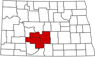
English: Locator map of the Bismarck Metropolitan Statistical Area in the southern part of the U.S. state of North Dakota. |
| Date | |
| Source | Own work |
| Author | LinkTiger |
Licensing
I, the copyright holder of this work, hereby publish it under the following license:
This file is licensed under the
Creative Commons
Attribution-Share Alike 4.0 International license.
- You are free:
- to share – to copy, distribute and transmit the work
- to remix – to adapt the work
- Under the following conditions:
- attribution – You must give appropriate credit, provide a link to the license, and indicate if changes were made. You may do so in any reasonable manner, but not in any way that suggests the licensor endorses you or your use.
- share alike – If you remix, transform, or build upon the material, you must distribute your contributions under the same or compatible license as the original.
File history
Click on a date/time to view the file as it appeared at that time.
| Date/Time | Thumbnail | Dimensions | User | Comment | |
|---|---|---|---|---|---|
| current | 03:38, 2 July 2020 |
| 258 × 154 (21 KB) | LinkTiger | Sioux County no longer part of MSA |
| 21:17, 30 July 2017 |
 | 258 × 154 (21 KB) | LinkTiger | User created page with UploadWizard |
File usage
The following pages on the English Wikipedia use this file (pages on other projects are not listed):
- Almont, North Dakota
- Bismarck, North Dakota
- Bismarck metropolitan area
- Burleigh County, North Dakota
- Carson, North Dakota
- Center, North Dakota
- Driscoll, North Dakota
- Elgin, North Dakota
- Flasher, North Dakota
- Fort Yates, North Dakota
- Glen Ullin, North Dakota
- Harmon, North Dakota
- Hebron, North Dakota
- Heil, North Dakota
- Leith, North Dakota
- Lincoln, North Dakota
- Mandan, North Dakota
- McKenzie, North Dakota
- Menoken, North Dakota
- Moffit, North Dakota
- Morton County, North Dakota
- New Leipzig, North Dakota
- New Salem, North Dakota
- Oliver County, North Dakota
- Raleigh, North Dakota
- Regan, North Dakota
- Sterling, North Dakota
- Wilton, North Dakota
- Wing, North Dakota
- Template:Bismarck-Mandan