
Size of this preview:
800 × 600 pixels. Other resolutions:
320 × 240 pixels |
640 × 480 pixels |
1,024 × 768 pixels |
1,280 × 960 pixels |
2,048 × 1,536 pixels.
Original file (2,048 × 1,536 pixels, file size: 1.09 MB, MIME type: image/jpeg)
| This is a file from the
Wikimedia Commons. Information from its
description page there is shown below. Commons is a freely licensed media file repository. You can help. |
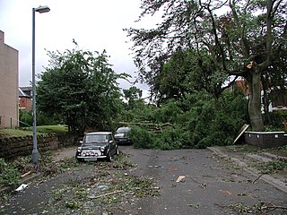
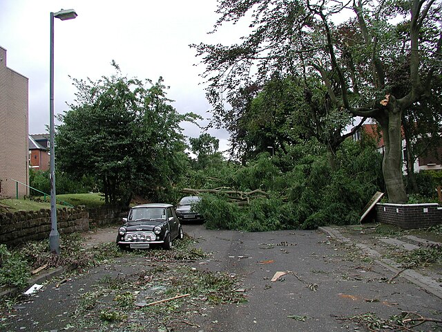
| Description | A street in Moseley the day after the Birmingham Tornado of 28 July 2005. | ||
| Date | Photographed by me. | ||
| Source | Photographed by Oosoom. | ||
| Author | User Oosoom on en.wikipedia | ||
| Permission ( Reusing this file) |
I, the copyright holder of this work, hereby publish it under the following licenses:
This file is licensed under the
Creative Commons
Attribution-Share Alike 3.0 Unported license.
You may select the license of your choice. |
||
| Other versions |
Originally from en.wikipedia; description page is (was) here * 16:32, 1 May 2006 [[:en:User:Oosoom|Oosoom]] 2048×1536 (1,137,846 bytes) <span class="comment">(Birmingham Tornado 28 July 2005)</span> |

| Camera location |
| View this and other nearby images on: OpenStreetMap |
|
|---|
File history
Click on a date/time to view the file as it appeared at that time.
| Date/Time | Thumbnail | Dimensions | User | Comment | |
|---|---|---|---|---|---|
| current | 14:34, 21 August 2006 |
| 2,048 × 1,536 (1.09 MB) | Liftarn | {{Information| |Description=A street in Moseley the day after the Birmingham Tornado of 28 July 2005. |Source=Photographed by Oosoom. |Date=Photographed 29 July 2005 by me. |Author=User Oosoom on [http://en.wikipedi |
File usage
The following pages on the English Wikipedia use this file (pages on other projects are not listed):
Global file usage
The following other wikis use this file:
- Usage on de.wikipedia.org
- Usage on el.wikipedia.org
- Usage on eo.wikipedia.org
- Usage on ru.wikipedia.org
- Usage on si.wikipedia.org
- Usage on zh.wikipedia.org