No higher resolution available.
Bergen_Hardangerfjord.png (511 × 506 pixels, file size: 97 KB, MIME type: image/png)
| This is a file from the
Wikimedia Commons. Information from its
description page there is shown below. Commons is a freely licensed media file repository. You can help. |
Summary
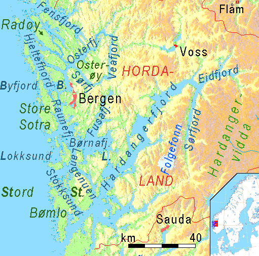
| Description | Physical map of Fjords and Sunds around Bergen and Hardangerfjord, showing the position of Fensfjord, Hjeltefjord, Osterøy, Osterfjord, Vedfjord, Sørfjord, Raunefjord,Børnafjord,Lokksund,Langenuen, Stokksund and Bømlo, Hardangerfjord with Sørfjord and Eidfjord. |
| Date | |
| Source | own work, using MAPS FOR FREE |
| Author | Ulamm |
| Other versions | Image:Bergen Stavanger Fjorde.png, prolonged by about 80 kilometers to the south |
Licensing
This file is licensed under the
Creative Commons
Attribution-Share Alike 3.0 Unported license.
- You are free:
- to share – to copy, distribute and transmit the work
- to remix – to adapt the work
- Under the following conditions:
- attribution – You must give appropriate credit, provide a link to the license, and indicate if changes were made. You may do so in any reasonable manner, but not in any way that suggests the licensor endorses you or your use.
- share alike – If you remix, transform, or build upon the material, you must distribute your contributions under the same or compatible license as the original.

|
This map image could be re-created using
vector graphics as an
SVG file. This has several advantages; see
Commons:Media for cleanup for more information. If an SVG form of this image is available, please upload it and afterwards replace this template with
{{
vector version available|new image name}}
.
It is recommended to name the SVG file “Bergen Hardangerfjord.svg”—then the template Vector version available (or Vva) does not need the new image name parameter. |
File history
Click on a date/time to view the file as it appeared at that time.
| Date/Time | Thumbnail | Dimensions | User | Comment | |
|---|---|---|---|---|---|
| current | 21:50, 30 January 2008 |
| 511 × 506 (97 KB) | Ulamm | |
| 15:19, 30 January 2008 |
 | 511 × 506 (97 KB) | Ulamm | ||
| 20:08, 29 January 2008 |
 | 511 × 506 (98 KB) | Ulamm | ||
| 14:12, 29 January 2008 |
 | 511 × 506 (97 KB) | Ulamm | ||
| 14:08, 29 January 2008 |
 | 511 × 506 (97 KB) | Ulamm | == Summary == {{Information |Description= Physical map of Fjords and Sunds around Bergen and Hardangerfjord, showing the position of Fensfjord, Hjeltefjord, Osterøy, Osterfjord, Vedfjord, Sørfjord, Raunefjord,Børnafjord,Lokksund,Langenuen, Stokksund an |
File usage
The following pages on the English Wikipedia use this file (pages on other projects are not listed):
Global file usage
The following other wikis use this file:
- Usage on bg.wikipedia.org
- Usage on cs.wikipedia.org
- Usage on da.wikipedia.org
- Usage on de.wikipedia.org
- Usage on es.wikipedia.org
- Usage on et.wikipedia.org
- Usage on fi.wikipedia.org
- Usage on fr.wikipedia.org
- Usage on is.wikipedia.org
- Usage on it.wikipedia.org
- Usage on nl.wiktionary.org
- Usage on nn.wikipedia.org
- Usage on no.wikipedia.org
- Usage on ru.wikipedia.org
- Usage on sl.wikipedia.org
- Usage on sv.wikipedia.org
- Usage on uk.wikipedia.org
- Usage on zh.wikipedia.org