No higher resolution available.
Belgieluik.png (398 × 335 pixels, file size: 6 KB, MIME type: image/png)
| This is a file from the
Wikimedia Commons. Information from its
description page there is shown below. Commons is a freely licensed media file repository. You can help. |
Summary
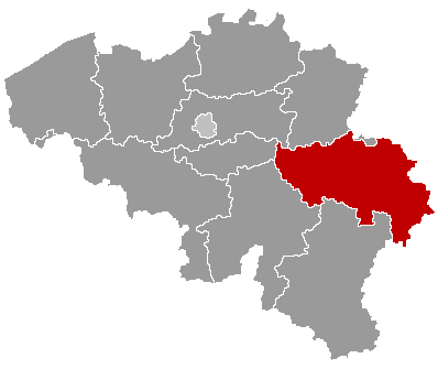
| Description | Map of Belgium with the 3 regions together, with the province of Liège colored red. |
| Date | |
| Source | Wikimedia Commons (Article 'Maps_of_Belgium') |
| Author | User 'Morwen' |
| Permission ( Reusing this file) |
none needed , seen the GNU Free Documentation License. |
Licensing

|
Permission is granted to copy, distribute and/or modify this document under the terms of the GNU Free Documentation License, Version 1.2 or any later version published by the Free Software Foundation; with no Invariant Sections, no Front-Cover Texts, and no Back-Cover Texts. A copy of the license is included in the section entitled GNU Free Documentation License. |
| This file is licensed under the Creative Commons Attribution-Share Alike 3.0 Unported license. | ||
| ||
| This licensing tag was added to this file as part of the GFDL licensing update. |
File history
Click on a date/time to view the file as it appeared at that time.
| Date/Time | Thumbnail | Dimensions | User | Comment | |
|---|---|---|---|---|---|
| current | 18:58, 24 May 2006 |
| 398 × 335 (6 KB) | Btrs | {{Information| |Description= Map of Belgium with the 3 regions togheter , with the province of Liège colored red. |Source=Wikimedia Commons (Article 'Maps_of_Belgium') |Date=24 May 2006 |Author=User 'Morwen' |Permission=none needed , seen the GNU Free Do |
File usage
The following pages on the English Wikipedia use this file (pages on other projects are not listed):
- Amay
- Amel
- Ans, Belgium
- Anthisnes
- Aubel
- Awans
- Aywaille
- Baelen
- Bassenge
- Berloz
- Beyne-Heusay
- Blegny
- Braives
- Burdinne
- Burg-Reuland
- Büllingen
- Bütgenbach
- Chaudfontaine
- Clavier, Liège
- Comblain-au-Pont
- Crisnée
- Dalhem
- Dison
- Donceel
- Engis
- Esneux
- Eupen
- Faimes
- Ferrières, Belgium
- Fexhe-le-Haut-Clocher
- Flémalle
- Fléron
- Geer
- Grâce-Hollogne
- Hamoir
- Hannut
- Herstal
- Herve
- Huy
- Héron
- Jalhay
- Juprelle
- Kelmis
- Lierneux
- Limbourg
- Lincent
- Liège
- Lontzen
- Malmedy
- Marchin
- Modave
- Nandrin
- Neupré
- Olne
- Oreye
- Ouffet
- Oupeye
- Pepinster
- Plombières
- Raeren
- Remicourt, Belgium
- Saint-Georges-sur-Meuse
- Saint-Nicolas, Liège
- Seraing
- Soumagne
- Spa, Belgium
- Sprimont
- St. Vith
- Stavelot
- Stoumont
- Theux
- Thimister-Clermont
- Tinlot
- Trois-Ponts
- Trooz
- Verlaine
- Verviers
- Villers-le-Bouillet
- Visé
- Waimes
- Wanze
- Waremme
- Wasseiges
- Welkenraedt
- User:Physchim62/Europa/Belgium
- User:SPQRobin/sandbox
- Template:Municipalities in Liège
Global file usage
The following other wikis use this file:
- Usage on ar.wikipedia.org
- Usage on bg.wikipedia.org
- Лиеж
- Лиеж (провинция)
- Уанз
- Юи
- Верлен
- Клавие
- Ерстал
- Сен Никола (Белгия)
- Вервие
- Вервие (окръг)
- Шаблон:Провинция Лиеж
- Амел
- Бален (Лиеж)
- Бург Ройланд
- Бюлинген
- Бютгенбах
- Келмис
- Лонцен
- Ойпен
- Ререн
- Санкт Вит
- Велкенрат
- Дизон
- Ерв
- Жале
- Лиерньо
- Лимбур
- Малмеди
- Обел (Белгия)
- Олн
- Пепенстер
- Пломбиер
- Ставело
- Стумон
- Тимистер-Клермон
- Троа Пон
View more global usage of this file.