
Size of this preview:
437 × 600 pixels. Other resolutions:
175 × 240 pixels |
350 × 480 pixels |
559 × 768 pixels |
746 × 1,024 pixels |
1,664 × 2,284 pixels.
Original file (1,664 × 2,284 pixels, file size: 140 KB, MIME type: image/png)
| This is a file from the
Wikimedia Commons. Information from its
description page there is shown below. Commons is a freely licensed media file repository. You can help. |
Summary
| Description |
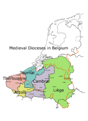
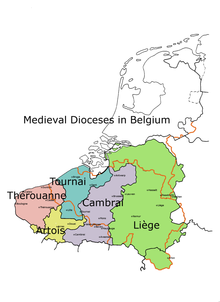
English: This is a map showing the old Catholic dioceses, which were to some extent based upon ancient Roman and pre-Roman territories. |
| Date | |
| Source |
Using Gimp software |
| Author | Andrew Lancaster |
| Other versions | Dutch translation: File:Low Countries Medieval Dioceses-NL.png |
Licensing
I, the copyright holder of this work, hereby publish it under the following licenses:

|
Permission is granted to copy, distribute and/or modify this document under the terms of the GNU Free Documentation License, Version 1.2 or any later version published by the Free Software Foundation; with no Invariant Sections, no Front-Cover Texts, and no Back-Cover Texts. A copy of the license is included in the section entitled GNU Free Documentation License. |
This file is licensed under the
Creative Commons
Attribution-Share Alike 3.0 Unported license.
- You are free:
- to share – to copy, distribute and transmit the work
- to remix – to adapt the work
- Under the following conditions:
- attribution – You must give appropriate credit, provide a link to the license, and indicate if changes were made. You may do so in any reasonable manner, but not in any way that suggests the licensor endorses you or your use.
- share alike – If you remix, transform, or build upon the material, you must distribute your contributions under the same or compatible license as the original.
You may select the license of your choice.
File history
Click on a date/time to view the file as it appeared at that time.
| Date/Time | Thumbnail | Dimensions | User | Comment | |
|---|---|---|---|---|---|
| current | 16:52, 15 June 2013 |
| 1,664 × 2,284 (140 KB) | Andrew Lancaster | Courtrai corrected to Tournai |
| 16:44, 15 June 2013 |
 | 1,664 × 2,284 (142 KB) | Andrew Lancaster | {{subst:Upload marker added by en.wp UW}} {{Information |Description = {{en|This is a map showing the old Catholic dioceses, which were to some extent based upon ancient Roman and pre-Roman territories.}} |Source = Using Gimp software<br/> '''Previousl... |
File usage
The following pages on the English Wikipedia use this file (pages on other projects are not listed):
Global file usage
The following other wikis use this file:
- Usage on ca.wikipedia.org
- Usage on es.wikipedia.org
- Usage on et.wikipedia.org
- Usage on it.wikipedia.org
- Usage on la.wikipedia.org
- Usage on nl.wikipedia.org
- Usage on www.wikidata.org