
Size of this preview:
698 × 600 pixels. Other resolutions:
279 × 240 pixels |
559 × 480 pixels |
894 × 768 pixels |
1,192 × 1,024 pixels |
2,384 × 2,048 pixels |
3,500 × 3,007 pixels.
Original file (3,500 × 3,007 pixels, file size: 6.72 MB, MIME type: image/png)
| This is a file from the
Wikimedia Commons. Information from its
description page there is shown below. Commons is a freely licensed media file repository. You can help. |
Summary
| Description |
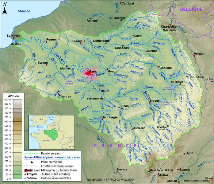
English: Topographic map of the
Seine basin in French, in png format, Lambert 93 projection
Français : Carte topographique du bassin de la
Seine en français, au format png, projection Lambert 93
Deutsch: Topografische Karte des hydrologischen Einzugsbereichs der Seine in französischer Sprache. Format: PNG Projektion: Lambert 93
|
| Date | |
| Source |
File:Topographic map of the Seine basin (French png).png;
|
| Author | Paul Passy ( Chamois rouge), completion Ulamm ( talk) |
| Other versions | see source |
.png)
Licensing
I, the copyright holder of this work, hereby publish it under the following licenses:

|
Permission is granted to copy, distribute and/or modify this document under the terms of the GNU Free Documentation License, Version 1.2 or any later version published by the Free Software Foundation; with no Invariant Sections, no Front-Cover Texts, and no Back-Cover Texts. A copy of the license is included in the section entitled GNU Free Documentation License. |
This file is licensed under the
Creative Commons Attribution-Share Alike
4.0 International,
3.0 Unported,
2.5 Generic,
2.0 Generic and
1.0 Generic license.
- You are free:
- to share – to copy, distribute and transmit the work
- to remix – to adapt the work
- Under the following conditions:
- attribution – You must give appropriate credit, provide a link to the license, and indicate if changes were made. You may do so in any reasonable manner, but not in any way that suggests the licensor endorses you or your use.
- share alike – If you remix, transform, or build upon the material, you must distribute your contributions under the same or compatible license as the original.
You may select the license of your choice.
File history
Click on a date/time to view the file as it appeared at that time.
| Date/Time | Thumbnail | Dimensions | User | Comment | |
|---|---|---|---|---|---|
| current | 22:50, 14 April 2019 |
| 3,500 × 3,007 (6.72 MB) | Ulamm | + Honfleur |
| 01:35, 22 January 2017 |
 | 3,500 × 3,007 (6.72 MB) | Ulamm | Motte Bucy, Romance | |
| 20:27, 21 January 2017 |
 | 3,500 × 3,007 (6.72 MB) | Ulamm | correction: one Nonette only | |
| 03:55, 21 January 2017 |
 | 3,500 × 3,007 (6.72 MB) | Ulamm | +3 | |
| 02:59, 21 January 2017 |
 | 3,500 × 3,007 (6.72 MB) | Ulamm | some more rivers and some lakes | |
| 13:21, 21 December 2016 |
 | 3,500 × 3,007 (6.69 MB) | Ulamm | revision of Laignes, relaunch of the scales-ruler | |
| 15:38, 14 November 2016 |
 | 3,500 × 3,007 (6.69 MB) | Ulamm | "Petites villes notables", merci bien :) | |
| 16:49, 13 November 2016 |
 | 3,500 × 3,007 (6.69 MB) | Ulamm | key completed | |
| 12:09, 12 November 2016 |
 | 3,500 × 3,007 (6.72 MB) | Ulamm | details in neighbouring regions | |
| 08:56, 12 November 2016 |
 | 3,500 × 3,007 (6.73 MB) | Ulamm | key adapted |
File usage
The following pages on the English Wikipedia use this file (pages on other projects are not listed):
Global file usage
The following other wikis use this file:
- Usage on arz.wikipedia.org
- Usage on ban.wikipedia.org
- Usage on br.wikipedia.org
- Usage on de.wikipedia.org
- Usage on el.wikipedia.org
- Usage on es.wikipedia.org
- Usage on fi.wikipedia.org
- Usage on frr.wikipedia.org
- Usage on fr.wikipedia.org
- Seine
- Marne (rivière)
- Oise (rivière)
- Aisne (affluent de l'Oise)
- Eure (rivière)
- Avre (affluent de l'Eure)
- Iton
- Risle
- Robec
- Epte
- Andelle
- Yvette (rivière)
- Yonne (rivière)
- Vesle
- Aube (rivière)
- Loing
- Bièvre (affluent de la Seine)
- Armançon
- Canal de la Marne au Rhin
- Vaucouleurs (rivière)
- Drouette
- Essonne (rivière)
- Orge (rivière)
- Vesgre
- Yerres (rivière)
- Canal Saint-Denis
- Fion
- Blaise (affluent de l'Eure)
- Canal du Nord (France)
- Aire (rivière)
- Aunette
- Juine
- Canal de l'Aisne à la Marne
- Canal de l'Oise à l'Aisne
- École (rivière)
- Grand Morin
- Ource
- Ourcq
- Douix
- Rémarde
- Réveillon (Yerres)
- Canal de Saint-Quentin
View more global usage of this file.