
Original file (SVG file, nominally 660 × 992 pixels, file size: 358 KB)
| This is a file from the
Wikimedia Commons. Information from its
description page there is shown below. Commons is a freely licensed media file repository. You can help. |
Summary
| Description |
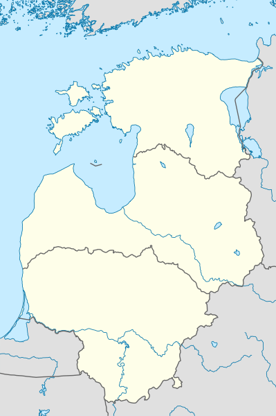
Deutsch: Positionskarte der
baltischen Staaten
Quadratische Plattkarte, N-S-Streckung 184 %. Geographische Begrenzung der Karte:
English: Location map of the
Baltic states
Equirectangular projection, N/S stretching 184 %. Geographic limits of the map:
|
|
| Date | ||
| Source |
Own work, using
|
|
| Author | NordNordWest | |
| Permission ( Reusing this file) |
This file is licensed under the
Creative Commons
Attribution-Share Alike 3.0 Germany license.
 This file is licensed under the
Creative Commons
Attribution-Share Alike 3.0 Unported license.
|


|
This map has been made or improved in the German
Kartenwerkstatt (Map Lab). You can
propose maps to improve as well.
|
File history
Click on a date/time to view the file as it appeared at that time.
| Date/Time | Thumbnail | Dimensions | User | Comment | |
|---|---|---|---|---|---|
| current | 21:01, 1 February 2011 |
| 660 × 992 (358 KB) | NordNordWest | == {{int:filedesc}} == {{de|Positionskarte der baltischen Staaten}} Quadratische Plattkarte, N-S-Streckung 184 %. Geographische Begrenzung der Karte: * N: 60.4° N * S: 53.7° N * W: 20.4° O * O: 28.6° O {{en|Location map of th |
File usage
- 2012–13 Baltic Basketball League
- 2015–16 Baltic Basketball League
- 2015–16 Baltic Men Volleyball League
- 2016–17 Baltic Basketball League
- 2016–17 Baltic Men Volleyball League
- 2017–18 Baltic Men Volleyball League
- 2020–21 Baltic Men Volleyball League
- 2021–22 Baltic Men Volleyball League
- Baltic Air Surveillance Network
- Baltic Hockey League
- Battle of Saule
- Jonava
- Kaunas
- Klaipėda
- Kuressaare
- Lyduvėnai
- Mažeikiai
- Nida, Lithuania
- Panevėžys
- Riga
- Telšiai
- Utena
- Vilnius
- Module:Location map/data/Baltic states
- Module:Location map/data/Baltic states/doc
Global file usage
The following other wikis use this file:
- Usage on ar.wikipedia.org
- Usage on ba.wikipedia.org
- Usage on bn.wikipedia.org
- Usage on ceb.wikipedia.org
- Usage on da.wikipedia.org
- Usage on de.wikipedia.org
- Benutzer:Spischot/Sketchpad 3
- Air Policing Baltikum
- BaltNet
- Wikipedia:Kartenwerkstatt/Positionskarten/Europa
- Vorlage:Positionskarte Baltische Staaten
- Benutzer:Gps-for-five/Spielwiese/Vorlage:Suche Poskarte
- Benutzer:Gps-for-five/Spielwiese/Vorlage:Suche Poskarte/Doku
- Vorlage:Suche Positionskarte
- Vorlage:Suche Positionskarte/Doku
- Livländisch-Estnischer Kriegsschauplatz
- Usage on es.wikipedia.org
- Usage on et.wikipedia.org
- Balti õhuseiresüsteem
- Mall:Asendikaart Baltimaad
- Võrkpalli Balti liiga 2021/22 hooaeg
- Võrkpalli Balti liiga 2022/23 hooaeg
- Võrkpalli Balti liiga 2020/21 hooaeg
- Võrkpalli Balti liiga 2019/20 hooaeg
- Võrkpalli Balti liiga 2018/19 hooaeg
- Võrkpalli Balti liiga 2023/24 hooaeg
- Võrkpalli Balti liiga 2017/18 hooaeg
- Võrkpalli Balti liiga 2016/17 hooaeg
- Võrkpalli Balti liiga 2015/16 hooaeg
- Võrkpalli Balti liiga 2005/06 hooaeg
- Võrkpalli Balti liiga 2006/07 hooaeg
- Võrkpalli Balti liiga 2007/08 hooaeg
- Võrkpalli Balti liiga 2008/09 hooaeg
- Usage on fa.wikipedia.org
- Usage on fr.wikipedia.org
- Usage on gl.wikipedia.org
- Usage on he.wikipedia.org
- Usage on id.wikipedia.org
- Usage on ja.wikipedia.org
View more global usage of this file.