
Original file (12,300 × 14,963 pixels, file size: 83.62 MB, MIME type: image/jpeg)
| This is a file from the
Wikimedia Commons. Information from its
description page there is shown below. Commons is a freely licensed media file repository. You can help. |
Summary
| Warning | The original file is very high-resolution. It might not load properly or could cause your browser to freeze when opened at full size. |
|---|
| Title |
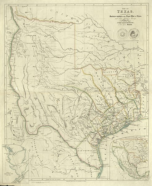
English: Map of Texas compiled from Surveys recorded in the Land Office of Texas and other official Surveys |
||||||||||||||||||||||||||
| Description |
English: John Arrowsmith's 1841 map of Texas was one of the first maps to show the new republic's most ambitious boundaries. These included the lower Rio Grande and not the Nueces River as the southern boundary with Mexico, the upper Rio Grande as the border with Mexican New Mexico, and the "stovepipe" panhandle stretching into what is now Colorado and New Mexico. This map appeared in Arrowsmith's London Atlas of Universal Geography first published in 1841 but other variants were included in his later atlases as well as in William Kennedy's popular travel and guide book Texas: The Rise, Progress and Prospects of the Republic of Texas, also published in 1841. Arrowsmith based his map upon a variety of sources from the republic's General Land Office, maps of competitors, travel accounts, and others. It includes the republic's original twenty-three counties plus additional counties formed up to 1839. Among the latter is a huge Robertson County, named for former empresario and pioneer Sterling Clack Robertson (1785-1842) whose right of claim to settle families in the area had led to a dispute with Stephen F. Austin and his partner Samuel May Williams. Arrowsmith's map was widely copied, notably the quote written across the Llano Estacado area of the panhandle that "This tract of Country explored by Le Grand in 1833 is naturally fertile well wooded & with a fair proportion of water" – a reference to Santa Fe trader Alexander Le Grand (ca.1794-1839) who purportedly surveyed the Wilson-Exter empresario grant before Texas became a republic. |
||||||||||||||||||||||||||
| Date | |||||||||||||||||||||||||||
| Source | UTA Libraries Cartographic Connections: map / text | ||||||||||||||||||||||||||
| Creator |
|
||||||||||||||||||||||||||
| Credit line |
English: The University of Texas at Arlington Libraries Special Collections, Gift of Virginia Garrett |
||||||||||||||||||||||||||
| Geotemporal data | |||||||||||||||||||||||||||
| Map location | Texas | ||||||||||||||||||||||||||
| Georeferencing | If inappropriate please set warp_status = skip to hide. | ||||||||||||||||||||||||||
| Bibliographic data | |||||||||||||||||||||||||||
| Publication |
The London Atlas of Universal Geography |
||||||||||||||||||||||||||
| Author |
|
||||||||||||||||||||||||||
| Place of publication | London | ||||||||||||||||||||||||||
| Publisher |
|
||||||||||||||||||||||||||
| Archival data | |||||||||||||||||||||||||||
| Collection |
|
||||||||||||||||||||||||||
| Dimensions | height: 62 cm (24.4 in); width: 52 cm (20.4 in) | ||||||||||||||||||||||||||
| Medium | colored engraving on paper | ||||||||||||||||||||||||||
| artwork-references |
Streeter, Thomas W. (1983) Bibliography of Texas 1795-1845 (2nd ed.), Woodbridge: Research Publications, Inc., no. 1120A, 1373 , pp. 371, 438 "Revised and Enlarged by Archibald Hanna" Martin, James C., and Robert S. Martin (1984, reprinted 1999) Maps of Texas and the Southwest, 1513-1900, Austin: Texas State Historical Association, no. 32 , pp. 126–127 Gournay, Luke (1995) Texas Boundaries: Evolution of the State's Counties, College Station: Texas A&M University Press, pp. 35–41 Raymond Estep (June 15, 2010). Le Grand, Alexander. Handbook of Texas Online. Texas State Historical Association. Retrieved on August 8, 2019. Malcolm D. McLean (June 15, 2010). Robertson, Sterling Clack. Handbook of Texas Online. Texas State Historical Association. Retrieved on August 8, 2019. |
||||||||||||||||||||||||||

Licensing

|
This file was provided to Wikimedia Commons by the
University of Texas at Arlington Libraries as part of a
cooperation project. The University of Texas at Arlington Libraries is part of the
University of Texas at Arlington, a public research university located in Arlington, Texas.
|
|
The author died in 1873, so this work is in the public domain in its country of origin and other countries and areas where the copyright term is the author's life plus 100 years or fewer. This work is in the public domain in the United States because it was published (or registered with the U.S. Copyright Office) before January 1, 1929. | |
| This file has been identified as being free of known restrictions under copyright law, including all related and neighboring rights. | |
File history
Click on a date/time to view the file as it appeared at that time.
| Date/Time | Thumbnail | Dimensions | User | Comment | |
|---|---|---|---|---|---|
| current | 14:36, 10 August 2019 |
| 12,300 × 14,963 (83.62 MB) | Michael Barera | == {{int:filedesc}} == {{Map |title = ''Map of Texas compiled from Surveys recorded in the Land Office of Texas and other official Surveys'' |description = {{en|John Arrowsmith's 1841 map of Texas was one of the first maps to show the new republic's most ambitious boundaries. These included the lower Rio Grande and not the Nueces River as the southern boundary with Mexico, the upper Rio Grande as the border with Mexican New Mexico, and the "stovepipe" panhandle stretching... |
File usage
Global file usage
The following other wikis use this file:
- Usage on ja.wikipedia.org
- Usage on ru.wikipedia.org