No higher resolution available.
Armadillo_range_expansion.png (420 × 290 pixels, file size: 19 KB, MIME type: image/png)
| This is a file from the
Wikimedia Commons. Information from its
description page there is shown below. Commons is a freely licensed media file repository. You can help. |
Summary
| Description |
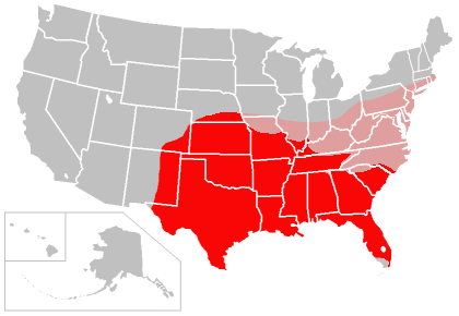
English: Map of the range of the
Nine-banded Armadillo in the
United States, created by
user:Caliga10. This map is based in part on the following maps:
with supplemental information folded into it related to the appearance of the Nine-banded Armadillo in southern Illinois, obtained from the Illinois Natural History Survey, and supplemental information related to the appearance of the Nine-banded Armadillo in western Kentucky, from [1] (anecdotal to be sure, but the Kentucky Department of Fish and Wildlife seems to agree). The areas colored red indicate present range of the Nine-banded Armadillo in the United States, as of approximately 2006, and the areas colored pink are areas in which the species should eventually be able to establish itself based on climate and soil conditions, according to the first source cited above. That source also indicated large areas of the west coast of the United States as being suitable for armadillo expansion, but that would depend on human intervention as the armadillo is not likely to be able to establish itself in points westward (i.e. the Rocky Mountains) which lie between its current range and the Pacific coast.עברית: תחום ההתפשטות של ארמדיל תשע-הטבעות, נכון ל2009–2010 ועתידי |
| Date | 4 December 2006 (original upload date) |
| Source | Own work by the original uploader |
| Author | Caliga10 at English Wikipedia |
Licensing
| This work has been released into the
public domain by its author,
Caliga10 at
English Wikipedia. This applies worldwide. In some countries this may not be legally possible; if so: Caliga10 grants anyone the right to use this work for any purpose, without any conditions, unless such conditions are required by law. |
Original upload log
Transferred from he.wikipedia to Commons by Fxp300.
The original description page was
here. All following user names refer to he.wikipedia.
- 2013-02-18 12:28 Manedwolf 420×290× (19845 bytes) == תקציר == {{מידע| |תיאור=תחום ההתפשטות של ארמדיל תשע-הטבעות, נכון ל2009–2010 ועתידי. |מקור=http://en.wikipedia.org/wiki/File:Armadillo_range_expansion.png |תאריך יצירה=כתוב ש...
The original description page was
here. All following user names refer to en.wikipedia.
- 2009-12-15 00:46 Caliga10 420×290× (19845 bytes) New version of this map for late 2009-early 2010, based on newspaper accounts that the armadillo is now moving into North Carolina.
- 2009-07-06 15:54 Caliga10 420×290× (19826 bytes) Uploaded a new version of this file which reflects expansion through mid-2009. The only significant change is the addition of most of East Tennessee per this source article: <ref>http://www.knoxnews.com/news/2009/jul/03/keeping-all-fingers-intact/</ref>-
- 2008-10-30 02:20 Caliga10 420×290× (24765 bytes) updated version of my armadillo range/expansion map from 2006 which factors in new source data indicating the armadillo's expansion has continued.
- 2006-12-04 00:47 Caliga10 420×290× (25087 bytes) Map of the range of the [[Nine-banded Armadillo]] in the [[United States]], created by [[user:Caliga10]]. This map is based in part on the following maps: [http://justinsomnia.org/images/armadillo_range.png Armadillo Range] [http://www.mnh.si.edu/mna//i
File history
Click on a date/time to view the file as it appeared at that time.
| Date/Time | Thumbnail | Dimensions | User | Comment | |
|---|---|---|---|---|---|
| current | 23:56, 13 September 2013 |
| 420 × 290 (19 KB) | OgreBot | (BOT): Reverting to most recent version before archival |
| 23:56, 13 September 2013 |
 | 420 × 290 (19 KB) | OgreBot | (BOT): Uploading old version of file from en.wikipedia; originally uploaded on 2009-07-06 15:54:17 by Caliga10 | |
| 23:56, 13 September 2013 |
 | 420 × 290 (24 KB) | OgreBot | (BOT): Uploading old version of file from en.wikipedia; originally uploaded on 2008-10-30 02:20:28 by Caliga10 | |
| 23:56, 13 September 2013 |
 | 420 × 290 (24 KB) | OgreBot | (BOT): Uploading old version of file from en.wikipedia; originally uploaded on 2006-12-04 00:47:02 by Caliga10 | |
| 16:04, 18 February 2013 |
 | 420 × 290 (19 KB) | HiyoriX | {{Information |Description={{he|תחום ההתפשטות של ארמדיל תשע-הטבעות, נכון ל2009–2010 ועתידי}} |Source=Transferred from [http://he.wikipedia.org he.wikipedia]; transfer was stated to be made by User:Fxp300.<b... |
File usage
The following pages on the English Wikipedia use this file (pages on other projects are not listed):
Global file usage
The following other wikis use this file:
- Usage on ceb.wikipedia.org
- Usage on he.wikipedia.org
- Usage on id.wikipedia.org
- Usage on ko.wikipedia.org
- Usage on pt.wikipedia.org