
Size of this preview:
520 × 600 pixels. Other resolutions:
208 × 240 pixels |
416 × 480 pixels |
780 × 900 pixels.
Original file (780 × 900 pixels, file size: 703 KB, MIME type: image/jpeg)
| This is a file from the
Wikimedia Commons. Information from its
description page there is shown below. Commons is a freely licensed media file repository. You can help. |
Summary
| Description |
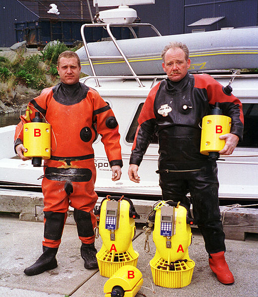
English: Dive team (Envirotech Divers) with an AquaMap long-baseline (LBL) acoustic positioning system. The three baseline transponders (B) are deployed prior to a dive and serve as the reference points for navigation. Using a short (2m) anchor line and a weight, they are secured to the seafloor. If repeat surveys need to be done over a period of time to monitor changes, the preferred technique is to establish a 'monument' at each baseline station location and secure the baseline station to that monument each time to minimize positioning variability. A monument may be a block of concrete, a railroad wheel or another heavy object. It may also be a distinctive natural feature such as a boulder. The divers navigate and record position using a terminal (A) similar to a GPS receiver. The terminal receives positioning data (baseline station distance and depth measurements) either from an integrated acoustic transponder, such as in the DS-1 station shown here, or from an external transponder. |
| Date | |
| Source | Own work |
| Author | Desertstar |
| Permission ( Reusing this file) |
Desert Star permission |
Licensing
I, the copyright holder of this work, hereby publish it under the following license:
This file is licensed under the
Creative Commons
Attribution 3.0 Unported license.
- You are free:
- to share – to copy, distribute and transmit the work
- to remix – to adapt the work
- Under the following conditions:
- attribution – You must give appropriate credit, provide a link to the license, and indicate if changes were made. You may do so in any reasonable manner, but not in any way that suggests the licensor endorses you or your use.
File history
Click on a date/time to view the file as it appeared at that time.
| Date/Time | Thumbnail | Dimensions | User | Comment | |
|---|---|---|---|---|---|
| current | 20:57, 17 May 2009 |
| 780 × 900 (703 KB) | Desertstar | {{Information |Description={{en|1=Dive team (Envirotech Divers) with an AquaMap long-baseline (LBL) acoustic positioning system. The three baseline transponders (B) are deployed prior to a dive and serve as the reference points for navigation. Using a sh |
File usage
The following pages on the English Wikipedia use this file (pages on other projects are not listed):
Global file usage
The following other wikis use this file:
- Usage on ca.wikipedia.org
- Usage on es.wikipedia.org
- Usage on fr.wikipedia.org